Geographical Framework & Administration:
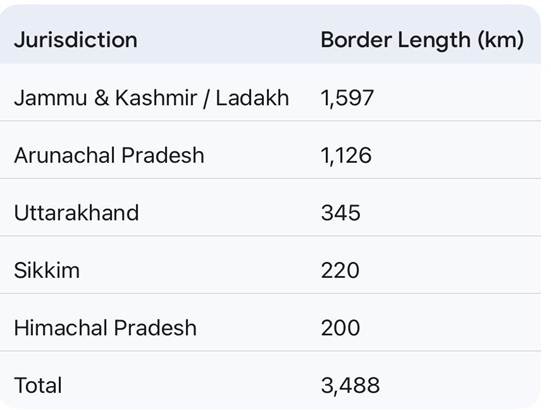
- Extent & Terrain: India shares a 3,488 km border with China, characterized by high-altitude, difficult terrain with limited infrastructure.
- Status: The boundary remains largely undemarcated, defined effectively by the Line of Actual Control (LAC).
- Security Management: The Indo-Tibetan Border Police (ITBP) acts as the primary border guarding force.
State-wise Border Distribution
- The border traverses one Union Territory (Ladakh) and four States:
Core Structural Disputes :
- Root Cause: The conflict stems from historical colonial demarcations. India accepts the McMahon Line (1914) as the legal boundary, which China repudiates.
Primary Contention Zones:
- Western Sector: Sovereignty over Aksai Chin.
- Eastern Sector: Claims over Arunachal Pradesh.
Chronology of Major Confrontations
- 1962 Sino-Indian War: A full-scale conflict triggered by disputes in Aksai Chin and Arunachal Pradesh, resulting in significant territorial shifts.
- 1967 Nathu La Clashes (Sikkim): PLA attacks on Indian posts were successfully repelled. India secured a decisive tactical advantage, destroying PLA fortifications.
- 2017 Doklam Standoff:
- Trigger: Chinese road construction in the Doklam tri-junction (disputed Bhutanese territory).
- Response: India launched Operation Juniper to support Bhutan.
- Resolution: A 73-day military standoff concluded with a mutual withdrawal of troops.
- 2020 Galwan Valley Clash (Ladakh): Triggered by Chinese objections to Indian infrastructure; this marked the first fatal confrontation since 1975, significantly deteriorating bilateral ties.
- 2022 Yangtse Skirmish (Arunachal Pradesh): Approximately 300 PLA troops attempted to encroach near Chumi Gyatse Falls. The attempt was thwarted after hand-to-hand combat.
Strategic India-China Border Regions & Passes: –
I. Western Sector: Ladakh
- Karakoram Pass: The northernmost pass connecting Ladakh to the Xinjiang region of China. It is a historic trade point on the ancient Silk Route and vital for high-altitude defense.
- Galwan Valley: A critical flashpoint located where the Galwan River meets the Shyok River; site of the 2020 standoff.
- Pangong Tso: A strategic endorheic lake extending from India to China; nearly two-thirds of the lake is controlled by China.
II. Middle Sector: Himachal Pradesh & Uttarakhand
- Shipki La: Located in Himachal Pradesh, this pass serves as a designated border trading post and the entry point of the Sutlej River into India.
- Lipulekh Pass: A significant tri-junction between India, Nepal, and China in Uttarakhand. It is the primary route for the Kailash Mansarovar Yatra pilgrimage.
III. Eastern Sector: Sikkim & Arunachal Pradesh (Tri-junctions)
- Nathu La: A major mountain pass in Sikkim connecting to the Chumbi Valley; it serves as one of the three open trading border posts between the two nations.
- Doklam: A plateau and tri-junction point between India (Sikkim), Bhutan, and China; strategically critical for the security of the Siliguri Corridor.
- Bum La Pass: A border pass in Arunachal Pradesh (Tawang District) used for Border Personnel Meetings (BPM) between the Indian Army and the PLA.
- Diphu Pass: A strategic tri-junction pass in eastern Arunachal Pradesh, marking the intersection of the Indian, Chinese, and Myanmarese borders.