Why in the News?
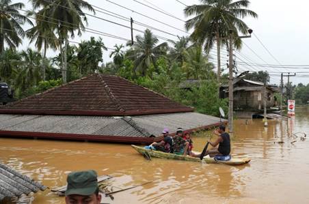
Cyclone Ditwah, which struck late November 2025, first battered Sri Lanka and then re-entered India — hitting coastal regions of Tamil Nadu and Andhra Pradesh with intense rainfall and gusty winds.
What happened — a factual snapshot
- Rainfall & flooding: Intense rain over a short period caused flash flooding and inundation of streets, low-lying localities, arterial roads and junctions. Drainage systems and pumps were unable to cope.
- Storm-drain failure: Existing drains — designed for lesser rainfall intensities — got overwhelmed; pumps were unable to manage sudden surges and reverse tidal flows, resulting in stagnation.
- Catchment response: The rivers draining into and through Chennai responded rapidly because urbanisation had reduced natural infiltration and storage zones; flood peaks could not be absorbed or delayed.
- Legacy of urban development: Encroachments, silted drains, loss of wetlands and floodplains, and impervious surfaces (roads, pavements) increased runoff volume and speed, reducing natural drainage and storage capacity.
The severity of the event thus resulted not only from the intensity of rainfall, but from a series of structural and systemic vulnerabilities accumulated over years.
Underlying drivers and systemic failures
Meteorological / Climate dimension
- Growing frequency of short-duration, high-intensity precipitation events — a pattern consistent with climate change trends.
- Coastal cyclonic systems combined with local convection can produce concentrated rainfall over small geographic zones — testing older design standards of urban drainage.
Urban morphology and land-use transformation
- Rapid urbanisation has led to loss of natural drainage systems, wetlands, floodplains and retention basins — areas that previously acted as buffers by absorbing and slowing down runoff.
- Encroachments into river floodplains and drainage channels have narrowed or blocked natural conveyance paths, forcing water to overflow into built-up areas.
- Increasing extent of impervious surfaces (roads, pavements, concrete surfaces) has reduced infiltration and increased surface runoff.
Infrastructure design, maintenance and adequacy gaps
- Existing drainage networks and pump systems were designed for less extreme rainfall intensities; they are not equipped for current extremes.
- Infrastructure works are often fragmented — e.g., new drains may be laid without complementary measures such as desilting, catchment conservation, or upstream storage; thus, the overall drainage capacity remains inadequate.
- Maintenance lapses — siltation of drains, lack of regular desilting, neglect of encroachment removal — reduce efficiency.
Governance, planning and institutional failures
- Absence of integrated, basin- or catchment-level planning. Urban agencies, municipal bodies, irrigation departments, coastal zone authorities and disaster management bodies often act in silos.
- Delay or non-implementation of recommended flood-management plans. For instance, a comprehensive basin-wise plan prepared by a committee remains largely unexecuted, lacking a consolidated funding and execution roadmap.
- Policy and regulatory failures: weak enforcement of zoning laws, floodplain regulations and controls on unauthorised construction or encroachment in high-risk areas.
- Lack of financing and accountability: Major flood-mitigation projects are planned, but they suffer from long gestation periods, unfunded mandates, or piecemeal funding, with no clear oversight mechanism.
Consequences: Immediate, medium-term and structural
- Human and economic damage: Flooding disrupted transport, stranded residents, damaged homes and small businesses, disrupted trade and livelihoods — especially of economically vulnerable groups.
- Health risks: Stagnant floodwaters can cause waterborne diseases; contamination and sanitation breakdown pose serious public-health hazards.
- Environmental degradation: Flooding and runoff can lead to soil erosion, degradation of aquatic ecosystems and loss of green cover; once wetlands are lost, biodiversity and natural absorption capacity reduces further.
- Loss of public trust and increased vulnerability: Recurring floods erode citizens’ confidence in governance; when systemic vulnerabilities remain unaddressed, future storms — even less severe — can result in major disasters.
- Urban resilience compromised: Without addressing structural weaknesses, cities remain exposed to increasing frequency of extreme weather events; adaptation remains superficial and reactive.
What should be done — Integrated, long-term solutions
To address these challenges and build resilient urban flood-management, a comprehensive strategy is required, combining infrastructure, ecological restoration, governance reform and community preparedness:
- Basin-level, multi-sectoral planning
- Move beyond isolated locality-driven works; plan at catchment level involving urban drainage, river management, floodplain regulation, wetlands protection and coastal defences.
- Use hydrologic-hydraulic (H–H) modelling, updated rainfall data and climate projections to redesign drainage systems for future extremes.
- Restore and protect natural drainage and retention zones
- Protect and restore wetlands, floodplains, retention ponds, wetlands corridors and natural water bodies that can act as buffers during heavy rainfall.
- Incentivise nature-based solutions like bioswales, urban wetlands, permeable pavements — reducing runoff and improving groundwater recharge.
- Modernise and upgrade drainage infrastructure with maintenance regime
- Upgrade drains and pump stations to handle higher discharge flows; incorporate anti-backflow measures and design for tidal surges in coastal areas.
- Institutionalise regular maintenance — periodic desilting, cleaning, encroachment removal, and drainage audits.
- Strengthen governance, regulations and institutional coordination
- Establish a single metropolitan flood-management authority (or similar institution) empowered across municipal and state boundaries to plan, implement and monitor flood mitigation infrastructure.
- Ensure legal enforcement of zoning, land-use and floodplain regulations — restrict construction in high-risk zones; provide stringent penalties for violations.
- Secure funding and ensure accountability
- Allocate multi-year, ring-fenced budgets for flood mitigation and resilience projects; explore blended financing (public funds, climate finance, PPPs) for large infrastructure investments.
- Use performance-based accountability — track project completion, maintenance schedules, and publish transparent progress reports.
- Community preparedness, early warning and adaptive capacity building
- Deploy real-time rainfall, river-level and drainage monitoring systems; issue timely alerts and advisories.
- Develop community evacuation plans, flood response measures, and pre-position emergency infrastructure (pumps, barriers, sandbags).
- Promote community awareness about floodplains, preserve green spaces, protect water bodies and discourage encroachments.
- Adopt a hybrid approach: infrastructure + ecology + planning
- Combine hard-engineering solutions with ecological and nature-based interventions for long-term urban resilience.
- Recognise that development and environment must co-exist — urban expansion must be balanced by safeguarding natural drainage and ecological buffers.
Conclusion
Cyclone Ditwah did not create the flooding crisis — it simply revealed a long-standing, layered failure of infrastructure, planning, governance and environmental stewardship. As extreme weather becomes more frequent under climate change, exposure and vulnerability will only grow — unless systemic reforms are undertaken.
The way forward lies not in ad hoc responses after every disaster, but in planned, integrated and forward-looking urban resilience — combining robust infrastructure, ecological restoration, rational land-use regulation, institutional coordination and community engagement. Only then can cities withstand nature’s fury without repeated devastation.
Source: Sting in the tail: on Cyclone Ditwah, its impact – The Hindu
Cyclone
- Cyclones are intense low-pressure systems characterized by strong winds circulating around a central low-pressure area (the eye).
- They form over warm ocean waters and derive energy from latent heat of condensation.
- Known by different regional names:
- Hurricane – Atlantic & Eastern Pacific
- Typhoon – Western Pacific
- Cyclone – Indian Ocean
- Willy-willy – Australia

Structure of a Tropical Cyclone
- Eye: Calm, clear region at the centre; lowest pressure.
- Eyewall: Surrounds the eye; most violent winds & heaviest rainfall.
- Rainbands: Spiral clouds extending outward; heavy showers.
- Outflow: High-altitude outward air movement stabilizing formation.
Conditions Required for Cyclone Formation
- Sea-surface temperature > 26.5°C (for heat & moisture)
- Large atmospheric instability (rapid condensation)
- Strong Coriolis force (hence not formed near Equator, ±5°)
- High humidity in lower–middle troposphere
- Low vertical wind shear (ensures vertical structure remains intact)
- Pre-existing low-pressure disturbance
Peak formation seasons
- North Indian Ocean: April–June & October–December
Stages of Cyclone Formation (Lifecycle)
- Tropical Disturbance
- Tropical Depression
- Tropical Storm (assigned a name)
- Severe Cyclone (full maturity)
- Landfall + Weakening
- Loses access to warm ocean moisture → decays
Classification of Cyclones (India)
(Based on maximum sustained wind speed – IMD scale)
| Category | Wind Speed |
| Depression | 31–49 km/h |
| Deep Depression | 50–61 km/h |
| Cyclonic Storm | 62–88 km/h |
| Severe Cyclonic Storm | 89–117 km/h |
| Very Severe Cyclonic Storm | 118–165 km/h |
| Extremely Severe Cyclonic Storm | 166–221 km/h |
| Super Cyclonic Storm | ≥ 222 km/h |
Impacts of Cyclones
Environmental & Geophysical
- Coastal flooding, storm surge
- Soil and groundwater salinity intrusion
- Destruction of mangroves & coral reefs
- Increased coastal erosion
Social & Humanitarian
- Loss of life & injuries
- Displacement and migration of communities
- Breakdown in communication & power supply
- Spread of waterborne diseases
Economic
- Damage to infrastructure: roads, bridges, ports
- Loss to agriculture, fisheries, industry
- High rehabilitation and reconstruction costs
Cyclones & Climate Change
- Increasing frequency of high-intensity cyclones
- Warmer oceans → greater moisture content → stronger storms
- Slower translation speed → prolonged impact on coastal regions
- Higher storm surges due to rising sea levels
Cyclone Prone Regions in India
- Bay of Bengal – more active due to:
- Warmer sea temperatures
- Landmass funnel shape increasing intensity
- Presence of large river deltas → vulnerable population
- Arabian Sea – recently increasing activity due to warming
East coast (Odisha, AP, TN, WB) faces most destructive cyclones.
Cyclone Forecasting & Early Warning in India
- IMD (Indian Meteorological Department) – nodal agency
- Uses: Doppler weather radars, satellites, ocean buoys, numerical weather prediction models
Cyclone Warning Dissemination Stages by IMD
- Pre-cyclone watch
- Cyclone alert
- Cyclone warning
- Post-landfall outlook
Disseminated through:
- SMS alerts
- TV/Radio broadcast
- Fishermen advisories
- Disaster management authorities
Disaster Risk Reduction & Management
Structural Measures
- Cyclone shelters, sea walls, storm-surge barriers
- Elevated infrastructure, resilient housing
- Strengthening embankments in deltas
Non-Structural Measures
- Coastal Regulation Zone (CRZ) compliance
- Mangrove restoration as natural defence
- Community preparedness & evacuation drills
- Insurance schemes and livelihood support
Policy & Institutional Measures
- National Cyclone Risk Mitigation Project (NCRMP)
- Sendai Framework guidelines for disaster resilience
- Multi-stakeholder coordination (NDMA, SDMAs, NDRF)
UPSC CSE PYQ
| Year | Question |
| 2013 | Why is the Indian Regional Navigation Satellite System (IRNSS) needed? How does it help in disaster management? |
| 2014 | Drought has been recognized as a disaster in India. Provide the reasons. |
| 2016 | The frequency of urban floods is increasing due to high-intensity rainfall and unplanned urbanization. Discuss. |
| 2016 | Discuss the role of Social Capital in Disaster Management. |
| 2017 | On December 2015, Chennai was hit by a devastating flood. Discuss the factors responsible for Chennai flood. |
| 2019 | What are the reformative steps taken by the Government to make Disaster Management more effective? |
| 2020 | Define ‘cloudburst’ and explain the reasons for occurrences of cloudbursts in India. |
| 2020 | Urban flooding is becoming a recurrent phenomenon in Indian cities. Discuss. |
| 2021 | “Disaster preparedness is the first step in any disaster management.” Explain. |
| 2022 | Elaborate the scope and significance of the Green Hydrogen Mission in the context of India’s energy needs. |
| 2022 | Describe the essential features of the National Disaster Management Plan 2016. |
| 2023 | Discuss the linkages between climate change, extreme weather events, and urban vulnerability in India. |
| 2023 | How prepared is India to tackle intensifying cyclones in the Indian Ocean? |
| 2024 | The growing number of hydrometeorological disasters in India indicates the need for integrated urban resilience planning. Discuss. |