Why in the News
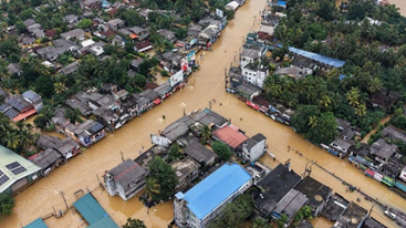
Recently, catastrophic floods and landslides caused by Cyclone Ditwah in Sri Lanka, cyclonic storms across Indonesia, centuries-scale rainfall in southern Thailand including Hat Yai, and Typhoon Kalmaegi in the Philippines including Cebu have dramatically exposed the inability of existing global liveability, prosperity and resilience indices to reflect the actual safety provided to citizens in an age when climate extremes are regularly breached.
Background and Context
- Major Indian metropolitan cities such as Mumbai, Delhi, Kolkata and Chennai are routinely treated as belonging to the same category in international rankings because of similar age, scale and cultural importance, yet the security offered to residents during cyclones and extreme monsoon events differs vastly among them – a divergence that has been starkly highlighted by recent disasters across Asia and that points to a deeper crisis in the way modern urban life is defined and measured worldwide.
- The standard approaches utilized globally to assess urban welfare are failing to provide a coherent way to judge whether a city truly affords its residents a “developed” life in the face of escalating climate challenges.
Prominent Urban Assessment Indices
Three prominent indices are currently employed to assess city performance and welfare:
- UN-Habitat City Prosperity Index: This combines productivity, infrastructure, quality of life, equity, environmental sustainability, and urban governance into a single comprehensive picture.
- Global Liveability Index: Cities are scored on stability, health care, culture and environment, education, and infrastructure.
- City Resilience Index: This focuses on the capacity of cities to withstand and recover from shocks, including extreme weather, across four key dimensions: health and well-being, economy and society, infrastructure and environment, and leadership and strategy.
Flaw in Existing Metrics
- While these approaches acknowledge the importance of economic output, public services, social inclusion, and environment to urban welfare, they are found to not yet add up to a coherent way to judge a city’s preparedness for a world of climate extremes.
Recent Climate Events: Exposing the Vulnerability
Recent severe flooding incidents in Asia have starkly exposed the shortcomings of existing urban metrics, particularly in secondary cities and peri-urban settlements.
Case Studies of Climate Extremes
- Sri Lanka: Cyclone Ditwah brought intense rain, causing flooding and landslides that resulted in over 400 deaths and the displacement of tens of thousands of people in Colombo and surrounding densely populated countryside settlements. Landslides in Sri Lanka also struck at night.
- Indonesia: Cyclonic storms triggered floods and landslides across Sumatra, killing hundreds and destroying villages situated in river valleys and on steep slopes.
- Thailand: Southern Thailand, including the city of Hat Yai, experienced rainfall reported as the heaviest in centuries, leading to floodwaters several metres deep, with national leaders acknowledging failures in warning systems. Families in South Thailand were reportedly trapped on upper floors for two days due to partial early warning and evacuations.
- Philippines: Typhoon Kalmaegi inundated parts of the Visayas region, including Cebu, resulting in dozens of deaths and the displacement of lakhs of people.
Exclusion of High-Risk Settlements
- Cities like Hat Yai and Cebu, which are secondary cities integrated into national economies, often do not appear on the major indices. Hill towns near Colombo are similarly linked to the capital’s labour and commodity markets but remain unlisted.
- This exclusion occurs because liveability rankings typically cover only capital regions and a small set of global hubs, while global city indices focus on financial and research functions.
- Consequently, the settlements that absorb much of the real risk of rapid urbanisation due to a changing climate are frequently excluded from the systems used to assess “modern” urban life.
Structural Shortcomings in Assessment Paradigms
The data and structural problems revealed by the floods indicate a failure in the design and focus of current assessment tools, leading to misaligned priorities and deepening risk.
Flaws in Recording and Measurement
- Inadequate Infrastructure Metrics: Where data does exist, the grey infrastructure in the most affected places was designed for weaker storms and was quickly overwhelmed by rainfall exceeding more than 300 mm in 24 hours. Liveability indices record the presence of essentials like hospitals, schools, parks, and public transport but are largely silent on crucial climate-related resilience factors:
- Whether drainage networks can handle 21st-century cloudbursts.
- Whether hillsides are free of construction.
- Whether safe and accessible alternatives to informal housing are available.
- Misleading Housing Stability: Prosperity indices may measure the share of households in “durable” housing but rarely differentiate between a secure brick house on a stable terrace and one cut into an unstable slope, thus mispricing the risk.
Investment Biases and Policy Misalignment
- Assessment paradigms have become a factor in how States and investors decide where to deploy capital.
- A city scoring highly on connectivity and business climate may attract more investment, even if it pays scant attention to drainage or slope stability, thereby deepening exposure in floodplains or unstable hillsides.
- Public officials are often incentivised to prioritise visible signs of modernity—airports, metro lines, and waterfront promenades—which “move the needle” in rankings.
- The less visible, yet critical, work of desilting canals, maintaining culverts, enforcing building codes, and relocating people towards sites of lower risk remains politically thankless.
Amplification of Inequity
- The use of city-wide averages in most indices misprices risk and disproportionately shifts the burden onto those with the lowest capacity to bear it.
- Rising land values and expanded infrastructure in flood-prone areas misleadingly reflect higher prosperity and better access.
- When extreme rain arrives, wealthier residents benefit from superior mobility, services, and can often protect themselves with insurance.
- In contrast, peri-urban settlers scramble in structures that crumble or flood first, despite residing in a city assessed to be “modern”.
- International funds and technical assistance often require certain plans and indicators, favouring cities that can already produce them (typically larger and more prosperous ones), making them the main recipients of adaptation support.
- Project design is consequently focused on satisfying reporting requirements rather than addressing the most acute local hazards.
- This cycle is reinforced as media, urban elites, planning curricula, and engineering standards adopt the vocabulary and biases of these global indices as reference points, embedding their biases into the next generation of urban professionals.
Way Forward: Restructuring Urban Assessment
The identified gaps in the assessment frameworks necessitate immediate action to integrate climate risk and equity into the definition of urban modernity.
- Revision of Index Parameters: The parameters of liveability and prosperity indices must be revised to include measures that assess the capacity of drainage networks to handle extreme rainfall and the stability of slopes and building sites, going beyond simple infrastructure presence.
- Refined Risk Measurement: Prosperity indices need to refine their measurement of housing quality to differentiate between durable housing on stable terrain and housing in unstable, high-risk areas like unstable slopes or floodplains, moving beyond city-wide averages.
- Prioritisation of Resilience: Funding and policy incentives must be redirected towards politically challenging but crucial work such as desilting canals, maintaining culverts, enforcing building codes, and relocating people from high-risk areas, rather than solely rewarding high-visibility projects like airports and metro lines.
- Equitable Adaptation Support: The criteria for distributing international funds and technical assistance for adaptation must be reformed to focus on acute local hazards and the needs of excluded settlements and vulnerable populations, rather than being determined by a city’s pre-existing capacity to satisfy reporting requirements.
- Incorporation of Local Risk: Planning curricula and engineering standards should cease adopting flawed global indices as the primary reference points and instead integrate local hazard mapping and vulnerability assessments as core components of urban development and investment decisions.
Conclusion
- Until the fundamental paradigms by which “modern”, “liveable” and “prosperous” cities are defined and measured are overhauled to centre the lived experience of climate extremes rather than the mere presence of visible infrastructure, millions of urban residents across Asia and beyond will continue to remain dangerously exposed beneath a veneer of global rankings.
- True urban modernity in the age of climate crisis must be judged not by airports and metro lines but by whether the most vulnerable citizen in the most hazard-prone settlement can survive the heaviest rain that the changed climate can now unleash.
UPSC MAINS PYQs
- Does urbanization lead to more segregation and/or marginalization of the poor in Indian metropolises? (2023)