Why in the News?
- Myanmar has recently commenced three-phase elections orchestrated by the military junta, nearly five years after it overthrew the democratically elected government led by the National League for Democracy (NLD).
- These elections are widely regarded as “sham polls”, aimed at legitimising military rule rather than reflecting the popular will of the people.
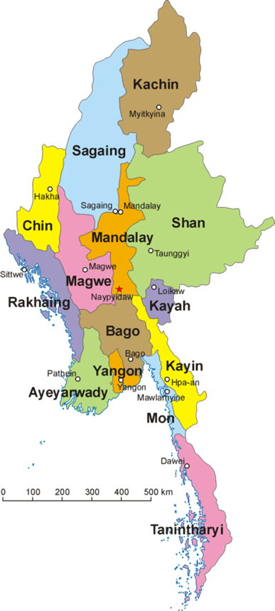
Key Locations in Myanmar’s Conflict Zones
1. Rakhine State
- Location: Western Myanmar, along the Bay of Bengal, bordering Bangladesh.
- Major Rivers: Kaladan River, Mayu River, Lemro River.
- Terrain: Narrow coastal plain rising to Arakan Mountains along the east.
- Vegetation: Tropical forests, mangroves along the coast, and hilly forests inland.
- Significance:
- Home to the Rakhine ethnic group and Rohingya population.
- Historically unstable with insurgency by the Arakan Army (AA).
- Strategic location for Indian Ocean access and trade routes.
2. Karenni State (Kayah State)
- Location: Eastern Myanmar, bordering Thailand.
- Major Rivers: Salween (Thanlwin) River, Pai River.
- Terrain: Mountainous, part of the Eastern Shan Hills, with steep valleys.
- Vegetation: Dense tropical forests and upland bamboo forests.
- Significance:
- Predominantly Karenni ethnic group; hotspot of ethnic armed insurgency.
- Contains People’s Defence Forces (PDFs) resisting junta control.
- Important for cross-border trade and insurgent supply lines.
3. Karen State (Kayin State)
- Location: Southeastern Myanmar, along the Thailand-Myanmar border.
- Major Rivers: Salween River, Moei River.
- Terrain: Hilly and mountainous, with lowlands along the Salween.
- Vegetation: Tropical and subtropical forests; fertile valleys in lowlands.
- Significance:
- Stronghold of Karen ethnic insurgent groups, including Karen National Union (KNU).
- Strategic for Myanmar-Thailand connectivity and ethnic autonomy movements.
4. Chin State
- Location: Northwestern Myanmar, bordering India’s Mizoram and Manipur and Bangladesh.
- Major Rivers: Chindwin River, Lemro River tributaries.
- Terrain: Extremely mountainous (Arakan Range), deep valleys, and rugged hills.
- Vegetation: Dense tropical and subtropical forests; temperate forests at higher elevations.
- Significance:
- Predominantly Chin ethnic group; difficult for military control due to terrain.
- Key for cross-border insurgency and humanitarian access issues.
5. Sagaing Region
- Location: Northwestern central Myanmar, bordering Nagaland and Arunachal Pradesh in India.
- Major Rivers: Chindwin River (major tributary of Irrawaddy), Irrawaddy River (southern boundary).
- Terrain: Mix of hilly terrain in the north and central plains along the Irrawaddy.
- Vegetation: Tropical forests in hills, fertile plains along rivers suitable for agriculture.
- Significance:
- Mix of Bamar majority and ethnic minorities.
- Centre of anti-junta resistance, including PDFs and ethnic militias.
- Critical for internal security and control over northern Myanmar.
Which of the following Myanmar states borders India’s Mizoram and Manipur?
(a) Rakhine State
(b) Chin State
(c) Karen State
(d) Karenni State

Answer: (b) Chin State

Explanation:
(a) Rakhine State: Incorrect. Rakhine State is in western Myanmar, along the Bay of Bengal, bordering Bangladesh, not India.
(b) Chin State: Correct. Chin State is in northwestern Myanmar, bordering India’s Mizoram and Manipur as well as Bangladesh. Its mountainous terrain (Arakan Range) and deep valleys make it difficult for the junta to control, and it has been a stronghold of ethnic resistance.
(c) Karen State: Incorrect. Karen (Kayin) State is in southeastern Myanmar, along the Thailand-Myanmar border, and does not share a border with India.
(d) Karenni State: Incorrect. Karenni (Kayah) State is in eastern Myanmar, also bordering Thailand, not India.