Why in the News?
- Recently, remote-sensing technology has gained renewed attention due to its expanding role in mapping vegetation health, forest biomass, surface and groundwater resources, flood inundation, and mineral occurrences from space.
- Advances in optical satellites, Synthetic Aperture Radar (SAR), hyperspectral imaging, and gravity-measurement missions have strengthened the ability to monitor Earth’s surface and subsurface resources accurately and non-invasively, making remote sensing indispensable for natural resource management, climate monitoring, and disaster response.
Concept of Remote Sensing
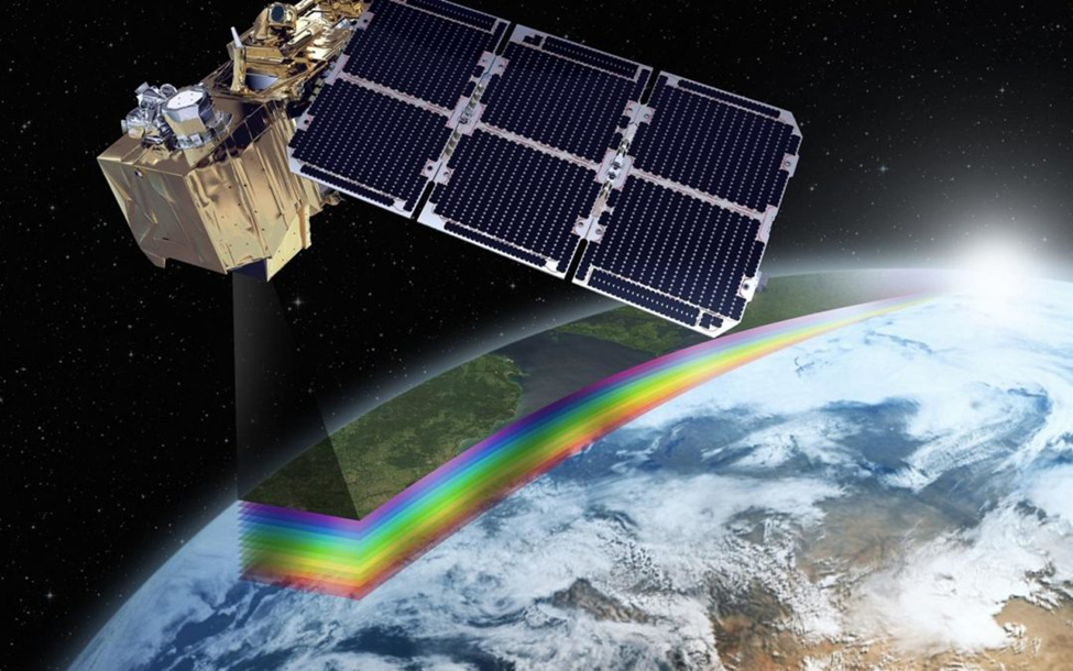
Remote Sensing is the process of detecting and monitoring the physical characteristics of an area by measuring its reflected and emitted radiation from a distance (typically from satellite or aircraft).
How It Works: The Spectral Signature
Remote sensing operates across a broad range of the electromagnetic spectrum, far beyond visible light. Every object on Earth has a unique “fingerprint” in the electromagnetic spectrum.
- Primary Energy Source: The Sun is the primary energy source, emitting radiation across visible, infrared, and ultraviolet wavelengths.
- Earth’s features such as vegetation, water, soil, and rocks absorb, reflect, or emit energy in distinct ways.
- Mechanism: When sunlight hits an object, the object absorbs some wavelengths and reflects others. The resulting pattern of interaction is called a spectral signature, which functions as a diagnostic identifier for materials
- Sensor’s Role: Sensors detect these reflections. For instance, Chlorophyll in healthy plants strongly absorbs red light but reflects Near-Infrared (NIR) light. A sensor seeing high NIR and low Red light identifies a “Healthy Plant.”
Types of Remote Sensors
- Passive Remote Sensors: Passive sensors measure naturally available radiation reflected or emitted from the Earth’s surface.
- They depend mainly on sunlight as the energy source.
- Their performance is limited during night-time and under heavy cloud cover.
- Examples include multispectral and hyperspectral optical sensors, Landsat MSS, IRS LISS, AVHRR.
- Active Remote Sensors: Active sensors emit their own electromagnetic energy and record the reflected signal.
- They can operate independently of sunlight.
- They can penetrate clouds, smoke, and rainfall.
- Synthetic Aperture Radar (SAR) is the most prominent active sensing technology.
- Examples: RADAR, LiDAR.
The Remote Sensing Process: Step-by-Step
The remote sensing process operates through imaging and non-imaging systems and follows a well-defined sequence of interrelated stages.
- Source of Electromagnetic Energy: The remote sensing process begins with an energy source that provides electromagnetic radiation to illuminate the target area, most commonly the Sun in passive remote sensing, while active systems such as radar and LiDAR generate and transmit their own energy towards the Earth’s surface.
- Modification of Radiation by the Atmosphere: As electromagnetic radiation travels from the source to the Earth, it interacts with atmospheric constituents like gases, aerosols, and water vapour, resulting in scattering and absorption, which selectively allow only certain wavelengths to reach the surface through atmospheric windows.
- Interaction of Energy with Surface Features: When radiation reaches the target, it interacts with surface materials by being reflected, absorbed, or transmitted, depending on the physical structure and chemical composition of objects such as vegetation, water, soil, or rocks, thereby generating a distinct spectral response.
- Sensing and Measurement of Returned Radiation: The radiation reflected or emitted from the target is captured by sensors mounted on satellites or aircraft, which measure the intensity of energy across specific wavelength bands and convert it into electrical and digital signals.
- Transmission and Processing of Sensor Data: The digitally recorded data are transmitted to ground receiving stations, where they undergo radiometric, geometric, and atmospheric corrections to remove distortions and are converted into usable image products.
- Interpretation and Analytical Evaluation: The processed imagery is examined using visual interpretation techniques such as tone, colour, shape, and texture, or through digital image analysis methods, to extract thematic information about land cover, vegetation health, or geological structures.
- Operational Application of Extracted Information: The final interpreted data are applied in practical fields such as agriculture, forestry, water resource management, mineral exploration, disaster monitoring, and environmental assessment, thereby completing the remote sensing process.
Use of Remote Sensing Technique
Remote sensing is a non-intrusive, large-scale technique to observe and monitor Earth’s surface and subsurface features, supporting resource management, environmental monitoring, disaster assessment, and sustainable development.
- Groundwater and Water Resources: Satellites can detect changes in groundwater levels by measuring gravity variations, as demonstrated by the NASA’s Gravity Recovery and Climate Experiment (GRACE mission;2002–2017).
- They help monitor aquifer depletion, support irrigation planning, and map water bodies using NDWI (Normalized Difference Water Index) and MNDWI (Modified Normalized Difference Water Index).
- Synthetic Aperture Radar (SAR) allows mapping of water even under cloud cover or during floods, while spectral signatures can monitor water quality, sediment, and algae content.
- Agriculture: Remote sensing enables crop identification, yield forecasting, and damage assessment due to droughts, pests, or other stresses.
- It assists in soil mapping, moisture estimation, and management of agricultural water resources.
- Vegetation indices such as NDVI help determine crop health, growth stage, and stress levels over large areas efficiently.
- Forestry and Ecosystem Monitoring: Satellites allow mapping of forest cover, biomass, and carbon storage, which is vital for climate change mitigation.
- Hyperspectral sensors can identify tree species, nutrient deficiencies, and underlying rock types.
- Can also detect alteration zones, where underground heat and fluids have chemically changed surface rocks, indicating potential mineralization.
- Estimating canopy chlorophyll content provides accurate information on ecosystem productivity and health.
- Coastal and Ocean Monitoring: Remote sensing monitors shoreline changes, coastal erosion, and sediment transport to support coastal management.
- Over oceans, satellites measure surface currents, temperature, wave height, and sea ice extent.
- Gravitational anomalies help detect subsurface geological features for marine resource exploration.
- Natural Resource and Mineral Exploration: Hyperspectral imaging enables detection of minerals such as copper, gold, and lithium, even in trace amounts.
- Satellites identify alteration zones caused by underground heat and fluids.
- In oil and gas exploration, remote sensing can detect micro-seepage affecting soil and vegetation.
- Structural Traps Detection: In absence of seepage, satellites detect geological structures capable of holding hydrocarbons, such as anticlines (upward-curving rock layers) and sedimentary basins.
- Satellites like NASA’s Landsat and Japan’sAdvanced Spaceborne Thermal Emissionand Reflection Radiometer (ASTER) on Terra capture surface rock folds, which indicate similar underground formations
- Measurements of Earth’s magnetic field and ocean topography further help identify subsurface reservoirs.
- Hazard and Disaster Assessment: Remote sensing tracks floods, hurricanes, earthquakes, and erosion, providing data for pre- and post-disaster planning, risk assessment, and mitigation.
- This helps in relief operations and disaster preparedness.
- Weather and Climate Monitoring: Satellites provide data on temperature, precipitation, and weather patterns at regional and global scales.
- Land Surface Temperature (LST) products assist in climate studies, urban heat monitoring, and agricultural planning.
- Atmospheric observations help track greenhouse gas emissions, such as methane, and identify emission hotspots to guide mitigation strategies.
India’s Progress in Remote Sensing and Space-Based Earth Observation
India has developed one of the world’s most extensive earth observation systems through the Indian Remote Sensing Satellite (IRS) programme by ISRO.
- The IRS-1A, launched in 1988, marked the beginning of operational remote sensing in India.
- The IRS satellites form the backbone of the National Natural Resources Management System (NNRMS) under the Department of Space (DoS).
Key National Institutions Supporting Remote Sensing
- Indian Institute of Remote Sensing (IIRS), Dehradun (Uttarakhand): The Indian Institute of Remote Sensing (IIRS) is a constituent institution of the Indian Space Research Organisation (ISRO) and plays a central role in strengthening India’s remote sensing and geospatial ecosystem.
- Functions of IIRS: Founded in 1966, IIRS has been instrumental in training, education, research, and capacity building in the fields of remote sensing, GIS, and geospatial applications.
- Regional and International Outreach of IIRS: The institute caters to national as well as international participants, with a special focus on capacity building in South and Southeast Asia.
- National Remote Sensing Centre (NRSC), Hyderabad: The National Remote Sensing Centre functions as the nodal operational agency for India’s remote sensing programme under ISRO.
- Core Responsibilities of NRSC: NRSC is responsible for remote sensing satellite data acquisition, processing, archiving, and dissemination, along with aerial remote sensing operations.
- Disaster Management Role of NRSC: The centre provides decision-support services for disaster monitoring, management, and response at national and state levels.
- Satellite Data Repository Function of NRSC: NRSC acts as the central hub for hosting satellite data products from more than 13 Indian Remote Sensing (IRS) satellites, including datasets from IRS-1A (first optical mission) and Synthetic Aperture Radar (SAR) imaging missions.
- Regional Remote Sensing Centres (RRSCs): The Regional Remote Sensing Centres operate as decentralised institutions that support the national remote sensing framework.
- Role of RRSCs: RRSCs assist in region-specific remote sensing applications while also contributing to national-level projects and programmes. RRSCs play an important role in extending technical support to state governments, regional planning bodies, and local agencies.
Indian Remote Sensing Satellites and National Resource Management
The Indian Remote Sensing (IRS) satellite series forms the core data source for the National Natural Resources Management System (NNRMS).
- The Department of Space (DoS) functions as the nodal agency for providing operational remote sensing services.
- Since the launch of IRS-1A in 1988, ISRO has deployed a wide range of satellites to meet civilian, environmental, and disaster management needs.
Recent Indian Earth Observation Satellites
| Satellite | Launch Year | Primary Use |
| EOS-07 | 2023 | Earth Observation |
| EOS-06 | 2022 | Earth Observation |
| EOS-04 | 2022 | Earth Observation |
| EOS-02 | 2021 | Earth Observation |
| EOS-01 | 2020 | Disaster Management, Earth Observation |
| RISAT-2BR1 | 2019 | Disaster Management, Earth Observation |
| Cartosat-3 | 2019 | High-Resolution Earth Observation |
| HysIS | 2018 | Hyperspectral Earth Observation |
With reference to India’s Air Defence System, consider the following statements:
1. The S-400 Triumf is an indigenously developed long-range surface-to-air missile system.
2. The Akash missile system uses command guidance and phased array radar to engage multiple airborne threats.
3. Integrated Counter-UAS grids are deployed along sensitive borders to neutralize hostile drones and UAVs.

Which of the statements given above is/are correct?
(a) 1 and 3 only
(b) 2 and 3 only
(c) 1 and 2 only
(d) All of the above

Answer: (b) 2 and 3 only

Explanation:
Statement 1 is incorrect: The S-400 Triumf is procured from Russia, not indigenously developed. It is a long-range SAM capable of intercepting aircraft, drones, and ballistic missiles up to 400 km.
Statement 2 is correct: The Akash missile system is indigenously developed and employs command guidance and phased array radar, allowing it to engage multiple airborne threats simultaneously.
Statement 3 is correct: Integrated Counter-UAS grids are deployed along sensitive borders to detect, jam, and neutralize hostile UAVs and drones, enhancing India’s airspace security.