Why in the News?
- Kurdish armed groups associated with the Syrian Democratic Forces (SDF) recently refused to withdraw from Kurdish-dominated neighbourhoods of Aleppo despite a ceasefire announced by the Syrian government.
- The episode has brought renewed attention to the Kurdish question, particularly the political status, security concerns, and autonomy demands of Kurdish-inhabited regions in West Asia.
Overview of Kurdistan
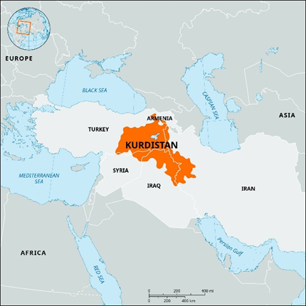
Kurdistan is located in West Asia, at the intersection of three major geographical zones: Anatolia, Mesopotamia, and the Iranian Plateau, that is traditionally inhabited by the Kurdish people.
- It is not an internationally recognised sovereign state, but a transnational ethnic homeland divided among several modern nation-states following post–World War I boundary settlements.
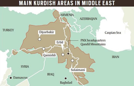
- Administrative Structure: The Kurdistan Region of Iraq is administratively organised into four governorates, namely Erbil, Sulaymaniyah, Dohuk, and Halabja.
- Capital City: Erbil functions as the capital city and serves as the political, administrative, and institutional headquarters of the Kurdistan Regional Government (KRG).
- Topography: The Kurdistan region is characterised by a rugged mountainous terrain, dominated by the Zagros Mountain system and the eastern extensions of the Taurus Mountains.
- The highest peak in the region is Cheekha Dar, located in northern Iraq, with an elevation of approximately 3,611 metres.
- Hydrography: The region is hydrologically significant, as several major rivers either originate from or flow through it, including the Tigris, Euphrates, Greater Zab, and Little Zab.
- Greater Zab River, one of the principal tributaries of the Tigris, flows almost entirely through Iraqi Kurdistan.
- Due to the presence of these river systems, the Kurdistan region is often described as the “water tower of the Middle East.”


Historical Timeline & Treaties
- Treaty of Sèvres (1920): Post-WWI agreement that promised an independent Kurdish state; it was never ratified.
- Treaty of Lausanne (1923): This treaty replaced Sèvres and omitted all mention of Kurdistan, effectively dividing the population among four different sovereign states.
- Anfal Campaign (1988): A genocidal campaign by the Iraqi regime against Kurds, including the Halabja chemical attack.
Human Geography: The Kurds
- The Kurds are a large ethnic group, predominantly Sunni Muslim, with a distinct cultural and historical identity in West Asia.
- They are predominantly Sunni Muslims and speak Kurdish, an Indo-Iranian language closely related to Farsi (Persian).
- The Kurds mainly inhabit a mountainous region spread across Turkey, Iraq, Iran, and Syria, with smaller populations in Armenia.
- The Kurdish population is estimated over approx. 30 million, making them the largest stateless ethnic group in the world.
- Iraq is the only country to grant the Kurds an autonomous region, known as the Kurdistan Region of Iraq, with its parliament established in 1992.
Geographical Extent and Borders of Kurdistan
Kurdistan region is located at a critical crossroads connecting Europe, Central Asia, and the Arab world, thereby enhancing its geopolitical importance.
- Kurdistan extends across a contiguous but politically fragmented mountainous belt spanning several countries. The region covers:
- Southeastern Turkey, where Kurds inhabit the highlands of Anatolia.
- Northern Iraq, which forms the core of the modern autonomous Kurdistan Region.
- Western Iran, particularly along the Zagros mountain slopes.
- Northern Syria, including enclaves such as those around Aleppo.
- Small southern portions of Armenia, near the Caucasus fringe.
- Borders: The Kurdistan region is bordered by Armenia and the Caucasus to the north, central Syria to the west, Iran to the east, and Arab-dominated plains of Iraq to the south.
- The absence of a unified political boundary makes Kurdistan a cross-border ethnic and geographical region, contributing to persistent regional tensions.
- Internal Boundaries: In Iraq, the “Green Line” historically separated the autonomous Kurdistan Region from the rest of Iraq.
- Disputed territories like Kirkuk (an oil-rich city on the ethnic fault line) remain a flashpoint between Erbil and Baghdad.
Climate, Vegetation, and Resources of the Kurdistan Region
- The Kurdistan region has a continental to semi-arid climate, with cold, snowy winters in the mountains and hot summers in lowlands.
- Rainfall is higher in mountainous areas and decreases towards the southern plains.
- The mountain slopes are characterised by oak forests and scrub vegetation, while alpine and sub-alpine grasslands support pastoral and nomadic livelihoods.
- Agriculture in valleys mainly produces wheat, barley, fruits, and nuts.
- Oil and natural gas resources are abundant, especially in northern Iraq and northeastern Syria, along with limestone and gypsum.
- Deforestation and overgrazing are growing environmental concerns, while resource wealth enhances the region’s strategic importance.
India–Kurdistan Region Relations
- Diplomatic Presence: India opened a consulate in Erbil in August 2016 to enhance economic, commercial, and people-to-people ties.
- Economic Engagement: Indian companies actively participate in trade fairs and business exhibitions in Erbil and Sulaymaniyah.
- Indian Workforce: Indian professionals work in Erbil, Sulaymaniyah, and Dohuk, mainly in steel, oil and gas, and construction sectors.
- Labour Contribution: Indian workers are valued for their technical expertise and professional skills in key industries.
With reference to the Kurdistan region, consider the following statements:
1. The Kurdistan region is characterised by rugged mountainous terrain, dominated by the Zagros Mountain system.
2. The Kurdistan region is an internationally recognised sovereign state.
3. The Kurdistan region is often called the “water tower of the Middle East” due to the presence of major rivers like the Tigris, Euphrates, Greater Zab, and Little Zab.

Select the correct answer:
(a) 1 and 3 only
(b) 2 and 3 only
(c) 1 and 2 only
(d) All of the above

Answer: (a) 1 and 3 only

Explanation:
Statement 1 is correct: The region is rugged and mountainous, dominated by the Zagros and Taurus ranges, and administratively consists of Erbil, Sulaymaniyah, Dohuk, and Halabja.
Statement 2 is incorrect: Kurdistan is not an internationally recognised sovereign state; it is a transnational ethnic region spanning Turkey, Iraq, Iran, Syria, and parts of Armenia.
Statement 3 is correct: The region is called the “water tower of the Middle East” due to major rivers such as the Tigris, Euphrates, Greater Zab, and Little Zab, which originate or flow through it.
Practice Today’s MCQs