Context
A new study published in the journal Earth’s Future by researchers at IIT Gandhinagar warns that while global warming is expected to increase flow in most major Indian rivers, the Cauvery Basin is an exception and will likely face a significant dry spell until 2050.
1. Key Findings of the Study
- Near-Term Decline: The basin faces a potential water decline of approximately 3.5% between 2026 and 2050.
- Long-Term Projection: Water levels are expected to rise only “negligibly” after 2051.
- Historical Data: Between 1951 and 2012, the Cauvery already experienced a 28% decline in streamflow.
- Contradictory Impact: Unlike northern rivers that may flood due to increased rainfall from warming, the Cauvery is unlikely to benefit from global warming-induced rain.
2. Potential Solutions
- River Interlinking: Projects like the proposed Godavari-Cauvery link could be necessary to mitigate the shortage.
- Statistical Modeling: The study used a novel “constrained modelling” approach to reduce errors often found in general climate models applied to Indian rainfall.
3. About the Cauvery Basin
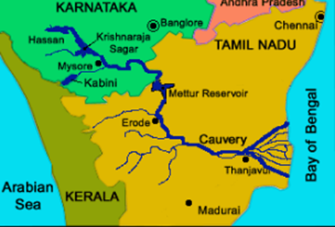
A. The Cauvery River Profile
- Origin: Rises at Talakaveri in the Brahmagiri Range of the Western Ghats (Kodagu district, Karnataka).
- Tributaries:
- Left Bank: Hemavati, Shimsha, Arkavati.
- Right Bank: Lakshmana Tirtha, Kabbani, Suvarnavati, Bhavani, Amaravati.
- Drainage: Cauvery is an easterly flowing river of the Peninsular India that runs across three of the southern Indian states i.e. Karnataka, Tamil Nadu, Kerala and a Union Territory of Puducherry.
- Major Projects: Krishnaraja sagar dam (Karnataka) , Mettur (Tamil Nadu) and Grand Anicut projects.
- Important Cities on the Bank of Cauvery River: Mysore, Mandya, and Kushalnagar in Karnataka, along with Erode, Tiruchirappalli (Trichy), Kumbakonam – Temple town, Thanjavur – Chola capital region and Mayiladuthurai in Tamil Nadu.
- Important temples on the banks of the Cauvery River: Ranganathaswamy Temple (Srirangam), Brihadishvara Temple (Thanjavur), and the Adikumbheshvara temple.
- Famous waterfalls on the Cauvery River:
- Shivanasamudra Falls
- One of the most famous waterfalls on the Cauvery
- Divided into Gaganachukki and Bharachukki falls
- Among the earliest sites of hydroelectric power generation in India
- Hogenakkal Falls
- Known as the “Niagara of India”
- Famous for coracle boat rides and scenic beauty
- Located on the Karnataka–Tamil Nadu border
- Key Wildlife Sanctuaries & National Parks on the bank of Cauvery River:
- Cauvery Wildlife Sanctuary, Ranganathittu Bird Sanctuary, Nagarahole National Park, and Sathyamangalam Tiger Reserve
B. Inter-State Water Disputes
- The Cauvery has a “fraught history” of water sharing between Karnataka and Tamil Nadu.
- Article 262 of the Constitution and the Inter-State River Water Disputes Act, 1956, govern these conflicts.
C. Climate Change & Hydrology
- Hydrological Drought: This study points toward a long-term hydrological drought in the basin despite overall national rainfall increases.
- Environmental Impact: Decline in flow affects the Kaveri Delta (the “Rice Bowl of South India”), groundwater recharge, and local biodiversity.
Which of the following protected areas lie in the Cauvery Basin?
1. Cauvery Wildlife Sanctuary
2. Ranganathittu Bird Sanctuary
3. Nagarhole National Park
4. Sathyamangalam Tiger Reserve

Select the correct answer:
A. 1 and 2 only
B. 1, 2 and 3 only
C. 1, 2, 3 and 4
D. 2 and 4 only

Answer: C
Explanation:
All the mentioned protected areas are situated within or are hydrologically linked to the Cauvery River Basin:
1. Cauvery Wildlife Sanctuary: Located in the Mandya, Ramanagara, and Chamarajanagar districts of Karnataka, the Cauvery River flows directly through this sanctuary, making it the most central protected area to the river's ecosystem.
2. Ranganathittu Bird Sanctuary: This consists of six small islands on the banks of the Cauvery River in Karnataka. It is a critical nesting ground for water birds that depend entirely on the river's flow.
3. Nagarhole National Park: Also known as Rajiv Gandhi National Park, its southern boundary is defined by the Kabini Reservoir, which is formed by the Kabini River—one of the largest and most important tributaries of the Cauvery.
4. Sathyamangalam Tiger Reserve: Situated at the confluence of the Western and Eastern Ghats in Tamil Nadu, its northern boundary is marked by the Cauvery River after it descends from the Karnataka plateau.