
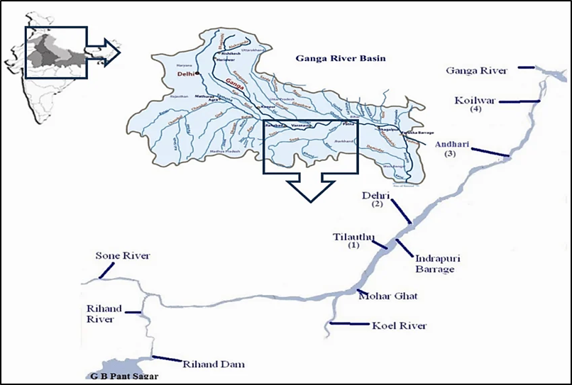
About Sone River
- Sone is a major perennial river and the second-largest southern (right-bank) tributary of the Ganga River system, after the Yamuna.
- Origin: Amarkantak Plateau near Pendra in the Gaurela-Pendra-Marwahi district of Chhattisgarh. The source lies just east of the headwaters of the Narmada River.
- Course: The river flows roughly 784 km through five states—Chhattisgarh, Madhya Pradesh, Uttar Pradesh, Jharkhand, and Bihar—before joining the Ganga at Maner (near Patna).
- Topographic Feature: The river parallels the Kaimur Range and forms a natural boundary between the Bhojpuri- and Magahi-speaking regions of Bihar.
- It is noted for its extremely wide bed (up to 5 km wide at Dehri) relative to its flow during dry seasons.
Tributaries
| Bank | Major Tributaries |
| Left-Bank Tributaries | Ghaghar, Johilla, Chhoti Mahanadi |
| Right-Bank Tributaries | Banas, Gopad, Rihand, Kanhar, North Koel |
Key Infrastructure on Sone river
- Bansagar Dam: Located in Shahdol district, Madhya Pradesh; operates as a multi-state venture between MP, UP, and Bihar.
- Rihand Dam (Govind Ballabh Pant Sagar): Built on the Rihand River (a primary tributary) near Pipri in Sonbhadra district, Uttar Pradesh.
- Indrapuri Barrage: Located at Dehri-on-Sone (Rohtas district, Bihar). It diverts water into the historic Sone Canal System, one of the oldest irrigation networks in India (commissioned in 1874).
- Koilwar Bridge (Abdul Bari Bridge): Constructed in 1862, it is India’s oldest operating double-decker rail-cum-road bridge, linking Arrah with Patna.
Conclusion
The Son River serves as a critical agricultural and ecological lifeline across Central and Eastern India. Balancing sustainable inter-state water governance with strict environmental safeguards against illegal sand mining remains essential to securing both regional water security and the long-term ecological health of the Ganga basin.
| This concept has been discussed elaborately in the following article: Bihar & Jharkhand Sone Water Agreement |