Context
In a first-of-its-kind initiative by any Indian state, the Government of Assam has floated a tender to launch a constellation of Earth-Observation (EO) Satellites, named AssamSAT. This project aims to provide high-resolution, real-time data to tackle the state’s chronic flood issues and enhance border security.
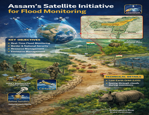
1. Key Objectives of the Project
- Real-Time Flood Monitoring: Tracking the Brahmaputra River’s course and inundation levels during monsoons to improve disaster response.
- Border & National Security: Monitoring the Siliguri Corridor (Chicken’s Neck) and porous international borders where traditional fencing is difficult.
- Environmental Protection: Detecting illegal logging, tracking drug trafficking routes, and preventing rhino poaching in Kaziranga National Park.
- Resource Management: Assessing crop health, forest cover, and urban planning across the state.
2. Technical Framework
- Orbit: The satellites will operate in Low-Earth Orbit (LEO).
- Constellation: A network of at least 5 satellites to ensure a high “revisit rate” (how often a satellite passes over the same spot).
- Satellite Type: Small satellites (Smallsats) or CubeSats, which are cost-effective and faster to deploy.
3. Science & Technology Linkages
A. Earth Observation Satellites (EOS)
- These are remote-sensing satellites designed for non-military uses such as environmental monitoring and meteorology.
- India’s RISAT (Radar Imaging Satellite) and Cartosat series are the national equivalents used for similar purposes.
B. Low-Earth Orbit (LEO) vs. Geostationary Orbit (GEO) vs Geosynchronous
| Feature | Low-Earth Orbit (LEO) | Geosynchronous Orbit (GSO) | Geostationary Orbit (GEO) |
| Altitude | 160 km to 2,000 km | 35,786 km | 35,786 km |
| Orbital Period | Approx. 90 to 120 minutes | 23 hrs, 56 mins, 4 secs (1 Sidereal Day) | 23 hrs, 56 mins, 4 secs |
| Speed | Very High (~27,000 km/h) | Matches Earth’s rotation speed | Matches Earth’s rotation speed |
| Position from Earth | Constantly moving/sweeping across the sky. | Returns to the same spot at the same time daily. | Appears fixed/stationary in the sky. |
| Inclination | Can be any (often Polar or Sun-synchronous). | Can be inclined (tilted relative to the equator). | Must be 0° (Directly over the Equator). |
| Latency (Delay) | Low (Minimal delay in signal). | High (Noticeable signal delay). | High (Noticeable signal delay). |
| Resolution | High Resolution (closer to Earth). | Lower resolution compared to LEO. | Lower resolution compared to LEO. |
| Primary Use Cases | Spy satellites, Remote Sensing, International Space Station (ISS), Starlink. | Specialized telecommunications, regional monitoring. | Satellite TV (DTH), Weather satellites (e.g., INSAT), Global Communication. |
C. Synthetic Aperture Radar (SAR) Technology
- Why it matters for Assam: Traditional optical cameras cannot see through clouds. During the monsoon, Assam is mostly cloud-covered.
- Mechanism: SAR uses radar pulses to create 2D or 3D images of landscapes. It can “see” through clouds, smoke, and darkness, making it essential for flood monitoring.
4. Strategic & Geographical Linkages
- The Siliguri Corridor: A narrow strip of land (~22km wide) in West Bengal that connects the North-Eastern states to the rest of India. It is a vital “choke point” for national security.
- Brahmaputra Hydrology: The river is “braided,” meaning it constantly changes its path. Satellite data helps in mapping these morphological changes which lead to sudden embankments breaches.
Q. With reference to the AssamSAT initiative, consider the following statements:

1. It aims to provide real-time flood monitoring of the Brahmaputra River.
2. It is India’s first national satellite constellation project.
3. It also focuses on border security in sensitive areas like the Siliguri Corridor.

Which of the statements given above is/are correct?
(a) 1 and 3 only
(b) 2 only
(c) 1 and 2 only
(d) 1, 2 and 3

Answer: A

Explanation:
•	Statement 1 is correct: One of the primary objectives of the AssamSAT initiative is to strengthen disaster response by providing real-time satellite monitoring of the flood-prone Brahmaputra valley.
•	Statement 2 is incorrect: While it is a significant project, Assam is the first Indian State to float a tender for its own group of earth-observation satellites. It is a state-level initiative rather than a "national" satellite constellation project (which would typically be led by a central agency like ISRO for the entire country).
•	Statement 3 is correct: The satellite mandate explicitly includes surveying the state's borders and monitoring sensitive areas like the Siliguri Corridor (the "Chicken's Neck"), which connects the Northeast to the rest of India.