Why in the News?
- China recently conducted large-scale live-fire military drills around Taiwan, simulating a blockade of key Taiwanese ports, under exercises code-named “Justice Mission 2025.”
- The drills were described by Beijing as a stern warning against “Taiwan independence”, reiterating China’s “One China” policy and claim over Taiwan.
- The exercises followed recent U.S. arms sales to Taiwan, which China termed as interference by external forces in its internal affairs.
- China declared temporary danger zones in air and maritime spaces near Taiwan, leading to disruption of international shipping lanes and aviation routes.
- Taiwan strongly condemned the drills as military intimidation, stating that they threaten regional stability and violate international norms of navigation and aviation safety.
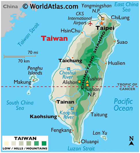
Taiwan: Location and Strategic Setting
Taiwan is a mountainous island in the Western Pacific Ocean, situated approximately 160–180 km off the southeastern coast of mainland China.
- Sovereignty: Officially known as the Republic of China (ROC); its political status remains a major flashpoint in international relations.
- Strategically located between the East China Sea (north) and the South China Sea (south), it serves as a critical maritime junction in the western Pacific.
- Taiwan lies along the First Island Chain, a series of archipelagos stretching from Japan through Taiwan to the South China Sea, making it vital for Indo-Pacific maritime security and regional geopolitics.
- Strategic Channels:
- Bashi Channel: South of Taiwan, separates it from the Philippines; connects the South China Sea to the Pacific Ocean.
- Miyako Strait: Northeast, a key maritime gateway between the East China Sea and the Pacific.
Boundaries and Surrounding Regions of Taiwan
- West: Bordered by the Taiwan Strait, which separates it from mainland China’s Fujian province.
- North: Adjacent to the East China Sea, connecting Taiwan to Japan’s southern islands.
- East: Faces the Philippine Sea, part of the western Pacific Ocean.
- South: Bordered by the South China Sea, a key international shipping corridor.
- Nearby regions: Japan’s Ryukyu Islands lie to the northeast, and the Philippines is situated to the south, highlighting Taiwan’s strategic location in regional geopolitics.
Physical Geography and Landforms of Taiwan
Taiwan’s topography is characterized by a sharp contrast between its eastern and western regions.
- Mountain Ranges: Rugged mountains cover about two-thirds of the island.
- Central Mountain Range: The “backbone” of the island, running north to south.
- Yu Shan (Jade Mountain): At 3,952 meters, it is the highest peak in Taiwan and the highest in East Asia.
- Plains: The western third of the island consists of flat, fertile coastal plains where the majority of the population and industries are located.
- Tectonic Activity: Taiwan lies at the complex convergent boundary of the Philippine Sea Plate and the Eurasian Plate. It is part of the Pacific Ring of Fire, making it highly prone to earthquakes.
Strategic Water Bodies of Taiwan
- Taiwan Strait: A narrow strait lying between Taiwan (east) and mainland China’s Fujian province (west). It is a major geopolitical flashpoint and a vital international shipping corridor connecting the East and South China Seas.
- East China Sea: Located to the north of Taiwan, it borders China, Taiwan, Japan, and South Korea. It is strategically important for regional trade routes, fisheries, and naval operations.
- South China Sea: Situated to the south of Taiwan, it links the Indian Ocean with the western Pacific Ocean. It is one of the world’s busiest maritime trade routes and a core area of strategic and territorial disputes.
- Philippine Sea: Located to the east of Taiwan, it forms part of the western Pacific Ocean. It is a deep oceanic region significant for naval deployments, submarine operations, and typhoon formation.
Drainage System (Major Rivers) of Taiwan
Taiwanese rivers are generally short and swift due to the steep mountain slopes, making them unsuitable for navigation but excellent for hydroelectric power.
- Zhuoshui River: The longest river in Taiwan (approx. 186 km), flowing westward from the Central Mountains into the Taiwan Strait.
- Gaoping River: The largest river by drainage area and volume, located in southern Taiwan.
- Tamsui River: The only major navigable river, flowing through the capital city, Taipei.
Climate and Vegetation of Taiwan
- Climate Zones: The Tropic of Cancer passes through the middle of the island, dividing it into:
- Subtropical Monsoon Climate in the north.
- Tropical Monsoon Climate in the south.
- Flora:
- Lowlands: Mangroves and tropical strand vegetation.
- Montane: Subtropical evergreen forests and broadleaf forests (Oak, Laurel).
- High Altitudes: Coniferous forests (Alpine Fir and Spruce).
- Fauna: Home to the Formosan Black Bear (endemic) and the endangered Formosan Landlocked Salmon.
Minerals and Economy of Taiwan
While Taiwan has limited mineral wealth compared to its industrial output, it remains a global economic powerhouse.
- Natural Resources: Small deposits of coal, natural gas, limestone, marble (found extensively in Hualien County), and sulfur (associated with volcanic areas like Yangmingshan).
- “Silicon Shield”: Taiwan is most famous for its Semiconductor Industry. It produces over 60% of the world’s semiconductors and over 90% of the most advanced chips, primarily through TSMC (Taiwan Semiconductor Manufacturing Company).
- Agriculture: High-quality Oolong tea, rice, and tropical fruits are major exports.
Strategic Significance
- Taiwan’s location along the First Island Chain makes it crucial for Indo-Pacific maritime security.
- The Taiwan Strait is a major shipping route, connecting the East China Sea with the South China Sea.
- Taiwan is a key player in global supply chains, particularly in electronics and semiconductors, making regional stability vital for international trade.
China has recently conducted large-scale military drills around Taiwan. Consider the following statements with reference to Taiwan:
1. Taiwan is officially known as the Republic of China (ROC).
2. It lies between the East China Sea to the north and the South China Sea to the south.
3. The Bashi Channel, located to the south of Taiwan, separates it from the Philippines.
4. Japan’s Ryukyu Islands are located to the northeast of Taiwan.

Which of the statements given above is/are correct?
(a) 1, 2 and 4 only
(b) 2 and 3 only
(c) 1, 3 and 4 only
(d) All of the above

Answer: (a) 1, 2 and 4 only

Explanation:
Statement 1: Correct – Taiwan is officially called the Republic of China (ROC). This is its formal political designation.
Statement 2: Correct – Taiwan is strategically located between the East China Sea to the north and the South China Sea to the south, making it an important maritime junction in the Western Pacific.
Statement 3: Incorrect – The Bashi Channel lies to the south of Taiwan and connects the South China Sea to the Philippine Sea, but it does not directly separate Taiwan from the Philippines. It is a maritime passage between Taiwan and the northern Philippines, but the statement’s wording is misleading.
Statement 4: Correct – The Ryukyu Islands of Japan are located to the northeast of Taiwan, forming part of the First Island Chain, which is significant for regional maritime security.