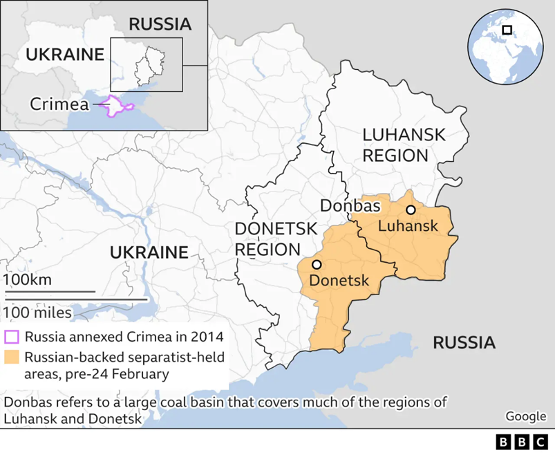
The Donbas region remains the focal point of the ongoing Russia-Ukraine conflict, frequently appearing in international headlines.
1. Political Map: Strategic Location
- Location: A historical, cultural, and economic region in Eastern Ukraine.
- Composition: Primarily encompasses two administrative regions (oblasts):
- Donetsk (South)
- Luhansk (North)
- Borders:
- East: Bordered by the Russian Federation.
- South: Reaches close to the Sea of Azov (Strategic maritime access).
2. Physical & Economic Geography
- Name Origin: An abbreviation of “Donets Basin” (named after the Donets River, a tributary of the Don River).
- River System: The Siverskyi Donets flows through the region, serving as a critical water source and natural barrier.
- Resource Wealth:
- Coal: One of the largest coal-mining regions in Europe (Donets Coal Basin).
- Industry: Historically the industrial heartland of Ukraine (Steel, Heavy Machinery).
3. Key Cities in Conflict
- Donetsk City: The largest industrial hub.
- Mariupol: A key port city on the Sea of Azov (located in Donetsk Oblast).
- Severodonetsk & Lysychansk: Strategic twin cities in the Luhansk Oblast.
Q. With respect to the economic significance of the Donbas region, consider the following statements:
1.It is one of the largest coal-mining regions in Europe.
2. Historically, it is known as the agricultural heartland of Ukraine.

Which of the statements given above is/are correct?
A. 1 only
B. 2 only
C. Both 1 and 2
D. Neither 1 nor 2

Answer: A

Explanation:

Statement 1 is Correct: The Donbas region (Donets Basin) is historically one of the largest coal-mining regions in Europe, rich in natural resources.
Statement 2 is Incorrect: The region is known as the industrial heartland of Ukraine, famous for heavy machinery, steel production, and mining, rather than being the "agricultural heartland."