Context
Recently, the Afghan military forces attacked Pakistani forces along the border, citing retaliation for deadly air strikes that occurred days earlier.
A spokesperson for the Taliban regime, Zabiullah Mujahid, stated that large-scale offensive operations were launched against Pakistani military bases and installations in response to repeated violations by the Pakistani military.
Key Aspects of Afghanistan
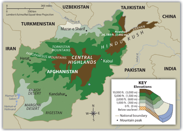
- Afghanistan, officially the Islamic Emirate of Afghanistan, is a landlocked, mountainous nation in South-Central Asia with a population of 38–50 million and Kabul as its capital.
- Political Features: It is a landlocked, mountainous country in Southern Asia, often referred to as the “Gateway to Asia.”
- Demographics & Language: Multiethnic population with Pashtun, Tajik, and Hazara as major groups. Official languages are Pashto and Dari.
- Bordering Nations: Turkmenistan, Uzbekistan, and Tajikistan to the north, Iran to west, Pakistan to the southeast, India and China to the northeast.
- Geographical Features:
- Hindu Kush Mountains: Dominant range, acting as a barrier.
- Wakhan Corridor: A narrow strip in the northeast connecting Afghanistan to China’s Xinjiang.
- Rivers: Amu Darya (North), Helmand River (Longest, Southwest), Kabul River (East).
- Passes: Khyber Pass (connects to Pakistan/Indian subcontinent).
- Desert: The Registan Desert, also called the Sistan Desert, is an extremely arid plateau in southeastern Afghanistan between Helmand Province and Kandahar Province.
- Highest Point: Mt. Nowshak
- Major Cities: Kabul (capital), Kandahar, Herat, Mazar-i-Sharif
- Climate & Extremes: Mostly arid to semi-arid climate with cold winters and hot summers.
- Key dams in Afghanistan: These are critical for irrigation and hydroelectric power, include the Salma Dam (Afghan-India Friendship Dam), Kajaki Dam(Helmand river), Kamal Khan Dam, and Dahla Dam.
- Economy & Resources:
- Main industries: textiles, carpets, cement, fertilizer.
- Agriculture: wheat, fruits, nuts, wool, opium.
- Minerals: Rich in natural resources like natural gas, lithium, copper, coal, iron ore, and precious stones.
- Major exports: carpets, wool, fruits, gems.
- Major imports: petroleum products, food, machinery.
Global Perspective
- INSTC: The International North–South Transport Corridor (INSTC) is a multi-modal trade route (ship–rail–road) connecting India with Central Asia, Russia, and Europe to reduce time and cost of transport.
- Regions involved: India, Iran, Afghanistan, Azerbaijan, Russia, Central Asia and Europe.
- BRI: China is integrating Taliban-led Afghanistan into the Belt and Road Initiative (BRI) to secure regional stability, access mineral resources, and boost trade connectivity, particularly by extending the China-Pakistan Economic Corridor (CPEC).
With reference to the Wakhan Corridor, consider the following statements:

I. It is a narrow strip of land located in northeastern Afghanistan.
II. It provides Afghanistan with a direct border with China.

Which of the statements given above is/are correct?

(a) I only
(b) II only
(c) Both I and II
(d) Neither I nor II.

Answer: C

Explanation:
•  Statement I is Correct: The Wakhan Corridor is explicitly identified as a narrow strip of land located in northeastern Afghanistan.
•  Statement II is Correct: The corridor acts as a "panhandle" that extends eastwards, providing Afghanistan with its only direct border with China at the Wakhjir Pass.