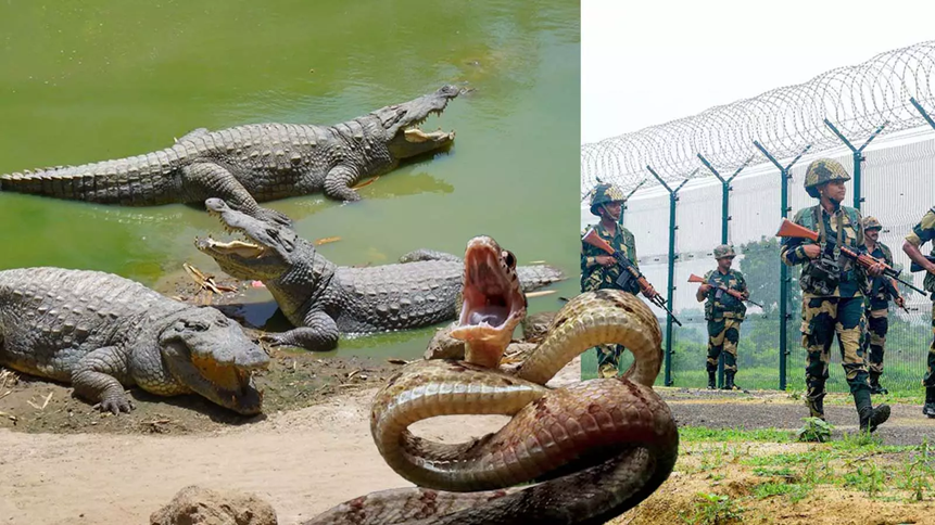
Context
Recently, the Border Security Force (BSF) has been directed to explore the feasibility of deploying predatory reptiles, such as crocodiles and snakes, to patrol the riverine gaps along the India-Bangladesh border. This directive, reportedly in line with instructions from the Union Home Ministry, aims to create a “biological deterrent” in areas where traditional physical fencing is impossible due to the difficult topography, frequent flooding, and shifting river courses.
1. The Geography of the India-Bangladesh Border
- Length: India shares its longest international land border with Bangladesh, stretching 4,096.7 km.
- States Involved: West Bengal, Assam, Meghalaya, Tripura, and Mizoram.
- Riverine Gaps: Approximately 175 km to 371 km (depending on seasonal flooding) consists of riverine stretches and marshy terrain (e.g., the Brahmaputra in Assam and the Ichamati in West Bengal).
- The “Porous” Nature: Unlike the desert or mountain borders, this boundary passes through densely populated villages, paddy fields, and rivers, making it one of the most complex borders to manage globally.
2. Security Challenges
- Infiltration & Illegal Migration: Porous riverine gaps are frequently used for illegal crossing.
- Transnational Crime: Smuggling of cattle, narcotics (like Phensedyl), and Fake Indian Currency Notes (FICN) is rampant.
- Anti-National Activities: The border serves as a conduit for insurgent groups in the Northeast to find safe havens.
3. Current Border Infrastructure Status
- Physical Fencing: Of the total sanctioned length, approximately 3,326 km has been approved for fencing, with roughly 2,954 km completed as of 2024-25 records.
- Floodlights: To curb nighttime activities, the government has sanctioned phase-wise installation of floodlights along the border.
- Technological Solutions (CIBMS): In areas where fencing is not feasible, the Comprehensive Integrated Border Management System (CIBMS) is deployed. This includes:
- Thermal imagers and infrared sensors.
- Underground and underwater sensors.
- Drones and high-resolution cameras.
4. The Proposal: “Biotic Patrols”
The internal communication within the BSF suggests exploring “biological barriers”:
- The Rationale: Crocodiles in the water and venomous snakes in marshy bushes could act as a psychological and physical deterrent to illegal crossers.
- Challenges Identified:
- Human-Wildlife Conflict: The border is densely populated; reptiles do not distinguish between a smuggler and a local villager.
- Ethical & Ecological Concerns: Introducing or augmenting predator populations can disrupt local ecosystems.
- Procurement & Control: Managing wildlife behavior in an open, flowing river system is practically impossible compared to “moats” used in ancient forts.
Q. With reference to the India-Bangladesh border management, consider the following statements:

1. The India-Bangladesh border is the longest land border shared by India with any neighboring country.

2. The Comprehensive Integrated Border Management System (CIBMS) is exclusively used for areas where physical fencing is already completed to provide a second layer of security.

3. The Border Security Force (BSF) is the primary agency responsible for guarding this international boundary.

Which of the statements given above are correct?
A) 1 and 2 only
B) 2 and 3 only
C) 1 and 3 only
D) 1, 2, and 3

Solution: C

• STATEMENT 1 IS CORRECT: India shares a 4,096.7 km border with Bangladesh, which is its longest land frontier.

• STATEMENT 2 IS INCORRECT: CIBMS (incorporating sensors, drones, and cameras) is specifically designed to provide "technological solutions" or "non-physical barriers" in difficult terrains like riverine gaps where physical fencing is not feasible.

• STATEMENT 3 IS CORRECT: The BSF is the designated "Border Guarding Force" for the borders with Pakistan and Bangladesh.