Context
Recently, Prime Minister Narendra Modi’s high-profile visit to Israel has brought the geography and strategic mapping of the Levant region back into sharp focus. The visit emphasized the “Special Strategic Partnership” between the two nations, highlighting key geographical corridors like the India-Middle East-Europe Economic Corridor (IMEC) and the strategic importance of the Port of Haifa.
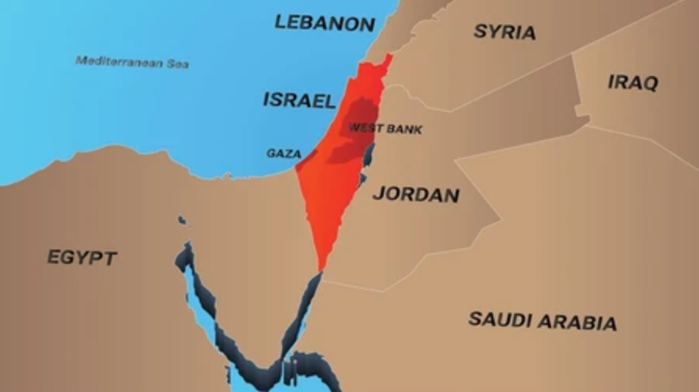
1. Political Geography & Borders
Israel is located at the eastern end of the Mediterranean Sea in West Asia, forming part of the Levant region.
- Northern Border: Lebanon (separated by the Blue Line).
- Northeastern Border: Syria (Golan Heights is the flashpoint).
- Eastern Border: Jordan and the West Bank.
- Southwestern Border: Egypt (Sinai Peninsula) and the Gaza Strip.
- Coastlines: It has a long western coastline on the Mediterranean Sea and a small southern exit to the Red Sea via the Gulf of Aqaba.
2. Disputed & Strategic Territories
- West Bank: A landlocked territory west of the Jordan River. It contains Judean Hills and key cities like Ramallah and Hebron.
- Gaza Strip: A coastal enclave on the Mediterranean, bordering Egypt at the Rafah Crossing.
- Golan Heights: A rocky plateau captured from Syria in 1967. It is strategically vital as it overlooks the Jordan River valley and provides a significant portion of Israel’s freshwater.
- Shebaa Farms: A small, disputed strip of land at the intersection of the Lebanese-Syrian border and the Israeli-occupied Golan Heights.
3. Physical Features
- The Negev Desert: Occupies the southern half of the country; it is a triangular-shaped semi-desert region.
- The Dead Sea: The lowest point on Earth (approx. 430m below sea level), shared with Jordan. It is hyper-saline.
- Sea of Galilee (Lake Tiberias): The primary freshwater lake in the north, fed by the Jordan River.
- Mountain Ranges: Includes Mount Hermon (highest point in the north), Mount Carmel (near Haifa), and the Judean Mountains.
4. Important Cities and Ports
- Jerusalem: Located in the Judean Mountains; the seat of government.
- Tel Aviv: The economic and technological hub on the Mediterranean coast.
- Haifa: The largest northern port city, critical for the IMEC project.
- Eilat: Israel’s only port on the Red Sea, located at the southern tip.
- Ashkelon & Ashdod: Major coastal cities and ports south of Tel Aviv.
Q. Consider the following pairs of geographical features and their locations:

                 Feature	Region/Bordering Body

1. Mount Hermon	Border between Israel and Lebanon/Syria
2. Gulf of Aqaba	Connects Israel to the Red Sea
3. Galilee	Located   in the Southern Negev region
4. River Jordan	Flows into the Mediterranean Sea

How many of the above pairs are correctly matched?

(a) Only one pair
(b) Only two pairs
(c) Only three pairs
(d) All four pairs

Solution: (b)

•	Statement 1 Correct: Mount Hermon is located in the northernmost part of the Golan Heights, acting as a boundary marker between Israel, Syria, and Lebanon.
•	Statement 2 Correct: The Gulf of Aqaba is the eastern arm of the Red Sea, providing Israel with maritime access through the port of Eilat.
•	Statement 3 Incorrect: Galilee is a lush, mountainous region in Northern Israel, not the southern Negev.
•	Statement 4 Incorrect: The Jordan River flows south from the Sea of Galilee and terminates in the Dead Sea, which is a terminal lake with no outlet to the Mediterranean.