Context
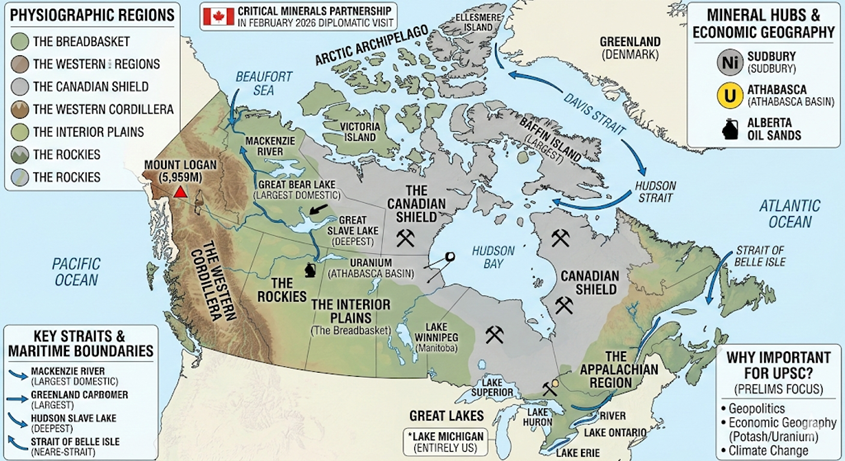
Recently, the visit of Canadian Prime Minister Mark Carney to India on February 27, 2026, has brought Canada’s geographical and strategic assets into sharp focus. A central pillar of the bilateral talks involves the India-Canada Critical Minerals Partnership. Canada’s geography is not merely a matter of topography but a repository of global resources; the Canadian Shield, often called the “Mineral House,” is vital for India’s transition to green energy, containing massive deposits of uranium, potash, and nickel.
1. Physiographic Regions
Canada is divided into seven distinct physiographic regions, each with unique geological features:
- The Canadian Shield: An ancient, horseshoe-shaped region of Precambrian rock surrounding Hudson Bay. It covers 50% of the country and is the primary source of metallic minerals (Iron, Nickel, Copper, Gold).
- The Western Cordillera: High, rugged mountains on the Pacific coast, including the Rockies and the Coast Mountains.
- The Interior Plains: The “Breadbasket of Canada,” stretching between the Shield and the Cordillera, known for wheat and fossil fuels.
- Appalachian Region: Older, eroded mountains in the southeast (Atlantic provinces).
- The Arctic Archipelago: A vast group of thousands of islands in the far north.
- St. Lawrence Lowlands: The most densely populated region, featuring fertile land and the Great Lakes.
- Hudson Bay Lowlands: A flat, swampy region located on the southern shore of Hudson Bay.
2. Mountain Systems and Ranges
- Western Cordillera (Pacific Coast):
- The Rockies: Extend from the US through British Columbia and Alberta.
- Coast Mountains: Run along the Pacific shore; they are heavily glaciated.
- Saint Elias Mountains: Home to Mount Logan (5,959m), Canada’s highest point.
- Eastern Systems:
- Torngat Mountains: Located in Labrador, part of the Canadian Shield.
- Appalachians: Low, rolling mountains in Newfoundland, New Brunswick, and Nova Scotia.
3. Hydrography: Rivers and Lakes
Canada contains 7% of the world’s renewable freshwater.
- Major Rivers:
- Mackenzie River: Longest in Canada (4,241 km); flows from Great Slave Lake to the Beaufort Sea.
- St. Lawrence River: Connects the Great Lakes to the Atlantic Ocean; a major commercial artery.
- Yukon River: Flows through the Yukon Territory into Alaska.
- Nelson River: Drains Lake Winnipeg into Hudson Bay.
- Key Lakes:
- The Great Lakes: Superior, Huron, Erie, and Ontario (Shared with the US). Lake Michigan is entirely in the US.
- Great Bear Lake: Largest lake entirely within Canada (Northwest Territories).
- Great Slave Lake: Deepest lake in North America (Northwest Territories).
- Lake Winnipeg: Located in Manitoba; a remnant of the glacial Lake Agassiz.
4. Strategic Islands and Straits
- Arctic Archipelago Islands: Baffin Island (largest), Victoria Island, and Ellesmere Island (northernmost).
- Strategic Straits:
- Davis Strait: Between Greenland and Baffin Island; connects Baffin Bay and the Labrador Sea.
- Hudson Strait: Connects Hudson Bay to the Atlantic Ocean.
- Strait of Belle Isle: Separates Newfoundland from the Labrador Peninsula.
- Juan de Fuca Strait: Between Vancouver Island and Washington State (US).
5. Major Minerals Found in Canada
Metallic Minerals
- Uranium: A globally significant resource. Canada possesses one of the world’s largest high-grade uranium reserves, primarily centered in the Athabasca Basin in northern Saskatchewan.
- Nickel: Extensive deposits are mined around Sudbury and Timmins in Ontario, making Canada a leading global producer.
- Potash: Essential for global agriculture. Canada is the world’s largest producer of potash, with major mines located across Saskatchewan.
- Iron Ore: Heavily concentrated in the Labrador Trough (the border region of Quebec and Newfoundland and Labrador).
- Copper, Gold, and Zinc: Widely distributed, with notable production centers in Ontario (Sudbury, Timmins) and Quebec.
Energy Minerals
- Crude Petroleum: Concentrated in Western Canada, specifically the Athabasca Oil Sands in Alberta. The Hibernia oil field off the coast of Newfoundland is also a major offshore producer.
- Natural Gas: Found extensively in British Columbia, Alberta, and Saskatchewan.
- Coal: Mined primarily in British Columbia, Alberta, and Saskatchewan.
Q. Consider the following statements regarding the mapping of Canada:

1. The Canadian Shield is an ancient geological region that encircles the Hudson Bay and is rich in metallic mineral deposits.
2. The Mackenzie River flows southwards from the Canadian Rockies to drain into the Pacific Ocean near Vancouver.
3. Baffin Island is the largest island in the Canadian Arctic Archipelago and is separated from Greenland by the Davis Strait.

Which of the statements given above are correct?
(a) 1 and 2 only
(b) 2 and 3 only
(c) 1 and 3 only
(d) 1, 2, and 3

Solution: (c) 1 and 3 only

•	STATEMENT 1 IS CORRECT: The Canadian Shield (Laurentian Plateau) is a vast area of Precambrian rock surrounding Hudson Bay and is a primary source of minerals like gold, nickel, and copper.
•	STATEMENT 2 IS INCORRECT: The Mackenzie River flows northwards from Great Slave Lake and drains into the Beaufort Sea (Arctic Ocean). The Fraser and Columbia rivers are the ones that flow toward the Pacific.
•	STATEMENT 3 IS CORRECT: Baffin Island is indeed Canada's largest island, and the Davis Strait (along with Baffin Bay) forms the maritime boundary between it and Greenland.