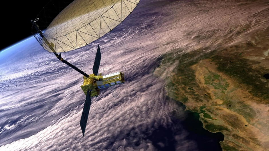
The NASA-ISRO Synthetic Aperture Radar (NISAR) satellite, launched on July 30, has officially transitioned from the commissioning phase to the Science Phase, marking the beginning of its data collection operations.
1. Mission Overview:
- Agencies Involved: A joint flagship mission between NASA (USA) and ISRO (India).
- Launch Vehicle: Launched onboard India’s GSLV Mk-II rocket from Sriharikota.
- Mission Life: 5 Years.
- Orbit: Placed in a Sun-Synchronous Polar Orbit at an altitude of 747 km.
- Current Status: The 12-meter antenna reflector is deployed, and the satellite has begun routine “science orbit” manoeuvres for calibration and data validation.
2. What makes NISAR unique?
NISAR is the first satellite to use Dual-Frequency Synthetic Aperture Radar (SAR). It operates on two distinct radio distinct bands to ensure all-weather, day-and-night imaging (penetrating clouds, smoke, and canopy).
- L-Band SAR (Provided by NASA):
- Frequency: 1.257 GHz (Longer Wavelength).
- Function: Penetrates dense forest canopies and soil layers.
- Usage: Detecting ground deformation, sub-surface movements, and woody biomass.
- S-Band SAR (Provided by ISRO):
- Frequency: 3.2 GHz (Shorter Wavelength).
- Function: Optimised for surface-level observation.
- Usage: Monitoring crop growth, soil moisture, and water levels.
3. Operational Mechanics: How does it scan the Earth?
- SweepSAR Technology: The mission utilizes a “SweepSAR” technique that allows for a wide swath (coverage area) of 240 km while maintaining high resolution.
- Resolution: Offers spatial resolution between 3 to 10 metres.
- Revisit Time: It will image the entire Earth’s land and ice masses every 12 days.
- Deformation Accuracy: Capable of detecting vertical land movements (subsidence/uplift) down to a centimetre.
4. Strategic Applications:
The data will be used for six broad themes:
- Cryosphere: Monitoring glacial melt, ice sheets, and sea-level rise implications.
- Disaster Management: Creating “Damage Proxy Maps” within 5 hours of natural disasters (floods, cyclones, earthquakes) to aid relief.
- Agriculture: precise estimation of crop acreage and soil moisture (critical for Rabi/Kharif planning).
- Ecosystems: Carbon stock estimation by measuring forest biomass.
5. Data Policy & Infrastructure
- Open Data Policy: All data generated will be freely available globally within hours of acquisition.
- Ground Stations:
- Global: NASA’s Near Earth Network (Alaska, Norway, Chile).
- India: ISRO’s stations in Shadnagar (Telangana) and Antarctica.