Why in the News?
- Recently, the Philippines evacuated nearly 3,000 residents from villages located on the slopes of Mayon Volcano after authorities raised the volcanic alert level to Level 3 due to increased activity.
- The evacuation followed mild eruptions, rockfalls, lava accumulation, and pyroclastic flows, highlighting the Philippines’ vulnerability to volcanic hazards as part of the Pacific Ring of Fire.
Geographical and Political Overview of Philippines
The Philippines is an archipelagic country in Southeast Asia, situated in the western Pacific Ocean.
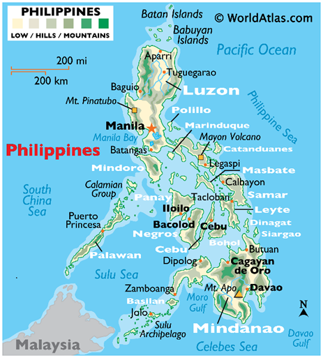
- Capital: Manila
- Strategic Placement: It lies between the Pacific Ocean and the South China Sea, making it geopolitically important in the Indo-Pacific region.
- Location: Situated within the Pacific “Ring of Fire,” an area of intense seismic and volcanic activity. It consists of more than 7,600 islands (updated from the previous count of 7,107).
- Regional Grouping: It is a key member of ASEAN, contributing to regional economic and security cooperation.
- Maritime Borders:
- Western Neighbour: The Philippines shares maritime proximity with Vietnam.
- Northern Neighbour: It lies south of Taiwan.
- Eastern Neighbour: Palau lies to the east across the Pacific.
- Southern Neighbours: The Philippines shares maritime boundaries with Malaysia and Indonesia.
- Surrounding Water Bodies:
- Eastern Boundary: The Philippine Sea, a part of the Pacific Ocean, lies to the east.
- Western and Northern Boundary: The South China Sea borders the country to the west and north.
- Southern Boundary: The Celebes Sea lies to the south.
- South-Western Boundary: The Sulu Sea separates parts of the Philippines from Borneo.
Key Characteristics of the Philippines
- Island Structure and Major Divisions: The Philippines is an archipelagic country comprising over 7,600 islands, broadly grouped into Luzon (Northern Philippines), Visayas (Central Philippines), and Mindanao (Southern Philippines).
- Terrain and Relief Features: The physical landscape is largely mountainous and rugged, interspersed with narrow coastal plains, reflecting its volcanic and tectonic origin.
- Tectonic Setting and Plate Location: The country is situated along major tectonic plate boundaries, placing it within an intensely seismically active zone.
- Mountains and Highest Peak: Mount Apo, located in Mindanao, is the highest peak of the Philippines at approximately 2,954 metres and is classified as a potentially active stratovolcano.
- Volcanic and Seismic Activity: The Philippines has 24 active and potentially active volcanoes, making volcanism a defining geological feature of the country.
- Most Active Volcano: Mayon Volcano, situated in Albay Province of Luzon, is the most active volcano and is internationally recognised for its near-perfect conical symmetry.
- Pacific Ring of Fire Location: The country lies within the Pacific Ring of Fire, which explains the frequent earthquakes, volcanic eruptions, and high geothermal activity.
- The belt is formed by interactions among several tectonic plates, with the Pacific Plate at the centre, interacting with the Philippine Sea, Indo-Australian, Eurasian, North American, South American, and Nazca Plates.
- Dominant Plate Process: Geological activity is mainly driven by convergent (subduction) boundaries, where denser oceanic plates sink beneath continental or island arc plates, generating earthquakes and volcanism.
- Climatic Characteristics: The Philippines experiences a tropical monsoonal climate, characterised by high temperatures and humidity throughout the year.
- Rainfall and Monsoon Influence: The country receives heavy seasonal rainfall, particularly during the southwest monsoon (Habagat).
- Cyclone and Storm Exposure: On average, around 20 typhoons and tropical storms pass through or affect the Philippines annually.
- Major River Systems: The Cagayan River is the longest river in the country, while the Mindanao River dominates southern drainage and the Agusan River flows into Butuan Bay, supporting agriculture, irrigation, and hydropower.
- Major Lake System: Laguna de Bay, the largest lake in the Philippines, is located near Metro Manila and plays a vital role in fisheries and water supply.
- Vegetation and Ecosystems: The country supports tropical rainforests, mangroves, and rich coastal ecosystems, reflecting its warm and humid climate.
- Natural Resource Base: The country is rich in nickel, cobalt, copper, gold, silver, and chromite, along with petroleum reserves.
- Renewable Energy Potential: Owing to its tectonic setting, the Philippines has strong renewable energy prospects, especially in geothermal power.
- Global Geothermal Rank: The Philippines is the third-largest producer of geothermal energy in the world, after the United States and Indonesia.
- World Heritage Significance: The Puerto-Princesa Subterranean River National Park, designated as a UNESCO World Heritage Site in 1999, is renowned for its underground river system that flows directly into the sea.
- Maritime Importance: The Philippines lies close to major Sea Lines of Communication (SLOCs) in the Indo-Pacific.
Q. Consider the following statements regarding the Philippines:
1.	The Philippines is an archipelagic country located entirely within the Pacific Ring of Fire, which explains its frequent volcanic eruptions and earthquakes.
2.	Mayon Volcano, located in Mindanao, is the highest and the most active volcano in the Philippines.
3.	The Philippine Sea lies to the east of the Philippines, while the South China Sea borders it to the west and north.
4.	The Philippines is the third-largest producer of geothermal energy globally, after the United States and Indonesia.

Which of the statements given above are correct?
(a) 1, 3 and 4 only
(b) 1 and 2 only
(c) 2 and 3 only
(d) 1, 2, 3 and 4

Answer: (a) 1, 3 and 4 only
Explanation:
•	Statement 1 – Correct. The Philippines lies within the Pacific Ring of Fire, a tectonically active zone characterised by frequent earthquakes and volcanic eruptions, making the country highly prone to geophysical hazards.
•	Statement 2 – Incorrect. Mayon Volcano is the most active volcano in the Philippines and is located in Albay Province, Luzon, not Mindanao. The highest peak of the Philippines is Mount Apo, located in Mindanao.
•	Statement 3 – Correct. The Philippine Sea lies to the east, while the South China Sea borders the Philippines to the west and north, making its maritime geography strategically significant.
•	Statement 4 – Correct. Due to its tectonic setting, the Philippines is the third-largest producer of geothermal energy globally, after the United States and Indonesia.