Why in the News ?
- Somaliland has recently gained global attention as Israel, the first UN member country, has formally recognised it as an independent and sovereign state.
- This recognition has highlighted Somaliland’s strategic location in the Horn of Africa and its role in maritime trade and security.
- Other countries, including Ethiopia, are reportedly considering recognition or closer engagement with Somaliland to secure port access and trade routes.
- Somalia has strongly opposed these moves, claiming Somaliland as an integral part of its sovereign territory.
Historical Background of Somaliland
- British Protectorate: Somaliland was under British protection from the late 19th century until the mid-20th century.
- Independence (1960): It gained independence as the State of Somaliland on 26 June 1960.
- Union with Italian Somaliland: On 1 July 1960, it merged with Italian Somaliland to form the Somali Republic.
- Post-Unification Marginalization: The northern regions faced political, economic, and administrative neglect.
- Siad Barre Regime: Repression during the 1970s–1980s led to civil unrest and displacement.
- Declaration of Independence (1991): Following Somalia’s collapse, Somaliland declared independence and established its own governing institutions.
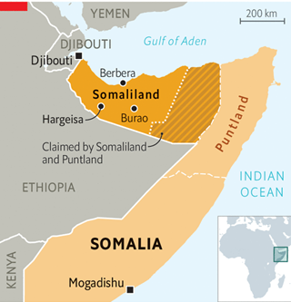
Geographical Location and Borders of Somaliland
Somaliland is situated in the Horn of Africa, occupying a pivotal position along the southern coast of the Gulf of Aden.
- Northern Border: It possesses an extensive coastline of approximately 850 km along the Gulf of Aden, which connects the Arabian Sea to the Red Sea via the Bab-el-Mandeb Strait.
- Northwestern Border: It shares a short land boundary with Djibouti.
- Western and Southern Borders: It is bordered by Ethiopia, which seeks access to the sea through Somaliland’s ports.
- Eastern Border: It borders the Puntland region of Somalia, a territory with which it has long-standing jurisdictional disputes.
Physical Geography and Landforms of Somaliland
The topography of Somaliland is diverse, ranging from coastal lowlands to rugged mountain ranges.
- The Guban Plain: A narrow, sandy, and arid coastal strip along the Gulf of Aden. It is characterized by high temperatures and low rainfall, making it a “heat zone.”
- Ogo and Golis Mountains: These are rugged mountain ranges that run parallel to the coast. The highest peak is Mount Shimbiris (approximately 2,460 meters), located in the Cal Madow range.
- The Haud Plateau: South of the mountains lies a vast, undulating plateau that extends into Ethiopia. This region is critical for nomadic pastoralism due to its seasonal grazing lands.
- Valleys: Notable landforms include the Nugal Valley and the Ain Valley, which consist of large seasonal drainage networks in the southeast.
Hydrology and Rivers of Somaliland
Somaliland lacks permanent, year-round rivers. Its hydrology is dominated by seasonal watercourses known locally as Wadis or Toggas.
- Togga Maroodi Jeex: A major seasonal river passing through the capital, Hargeisa, vital for local water supply during rainy seasons.
- Drainage Patterns: Most seasonal streams in the north flow toward the Gulf of Aden, while those in the south and east drain toward the Indian Ocean through the larger Somali plateau systems.
Climate and Vegetation of Somaliland
- Climate: The region experiences an Arid to Semi-Arid climate. It is characterized by four distinct seasons: Gu (main rainy season), Xagaa (dry and windy), Deyr (short rains), and Jiilaal (long dry season).
- Vegetation: Due to sparse rainfall, the vegetation is primarily Xerophytic (drought-resistant).
- Species: Common flora includes Acacia trees, thorny shrubs, and various species of Frankincense and Myrrh trees, for which the region has been famous since antiquity.
- Ecosystems: The highlands support sparse juniper forests and boxwood, while the lowlands are dominated by semi-desert scrub.
Mineral Wealth and Natural Resources of Somaliland
Somaliland is considered highly prospective but remains largely underexplored.
- Gemstones: The region is a rich source of Emeralds, Rubies, Sapphires, and Aquamarines, found primarily in the crystalline basement rocks.
- Metallic Minerals: Significant deposits of Gold, Iron Ore, Tin, Copper, and Zinc have been identified.
- Industrial Minerals: It holds massive reserves of Gypsum (among the largest in the world), as well as Marble, Mica, and Quartz.
- Hydrocarbons: Seismic surveys indicate high potential for Oil and Natural Gas reserves both onshore and offshore in the Gulf of Aden.
Strategic Importance of Somaliland
- Geopolitical Location: Somaliland lies at the crossroads of the Indian Ocean and the Red Sea, making it a critical point for global maritime trade.
- Berbera Port: Provides access to some of the world’s busiest shipping lanes, crucial for international commerce.
- Maritime Security: Shipping routes near Somaliland have been threatened by Yemen’s Houthi militia, underlining its strategic security relevance.
Why is Somaliland considered strategically important in international geopolitics?
(a) Its proximity to the Suez Canal and the Mediterranean Sea.
(b) Its position along the Gulf of Aden and access to the Bab-el-Mandeb Strait.
(c) Its large freshwater lakes suitable for hydroelectricity.
(d) Its mountainous terrain ideal for tourism.

Answer: (b)

Explanation:
(a) Suez Canal/Mediterranean: Incorrect – Somaliland is not near these; strategic importance comes from the Gulf of Aden.
(b) Gulf of Aden/Bab-el-Mandeb: Correct – Somaliland’s coastline (~850 km) provides access to a major maritime chokepoint, crucial for trade, energy transport, and regional security.
(c) Freshwater lakes: Incorrect – Somaliland has no large lakes; rivers are seasonal.
(d) Mountains/tourism: Incorrect – Mountains exist, but strategic value is maritime, not tourism.