Why in the News?
- Recently, U.S. President Donald Trump indicated that the United States had conducted a targeted strike on a “major plant or facility” in Venezuela, reportedly linked to maritime narcotics trafficking.
- This follows a high-intensity pressure campaign where the U.S. military has neutralized over 105 alleged drug boats in the Caribbean and Pacific since September.
- This development marks a significant shift from maritime interceptions to direct land-based operations against Venezuelan infrastructure, escalating regional geopolitical tensions and raising concerns over sovereignty and international law.
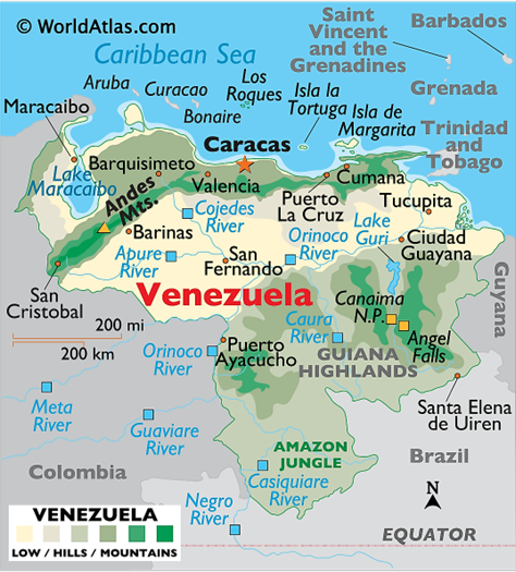
Overview: Geography of Venezuala
Venezuela is located at the northern extremity of South America, holding a strategic position overlooking major sea lanes.
- Land Borders: Shared with three sovereign nations:
- Colombia (West & Southwest): Shares the longest border (~2,219 km); the frontier is marked by the Andes and the Orinoco basin.
- Brazil (South): The border runs through the remote and dense Amazonian rainforests and the Guiana Highlands.
- Guyana (East): Shares a border currently subject to a severe territorial dispute over the Essequibo region, which Venezuela claims as Guayana Esequiba.
- Maritime Boundaries: It is bounded by the Caribbean Sea and the Atlantic Ocean to the north. It shares maritime boundaries with the U.S. (Puerto Rico/Virgin Islands), the Netherlands (Aruba/Bonaire/Curaçao), and Trinidad and Tobago.
- Archipelagos: Administers numerous islands, including Margarita Island, Los Roques, and the Aves Island (a strategic outpost in the Caribbean).
Physical Landforms of Venezuala
Venezuela is categorized into four primary physiographic regions:
- The Maracaibo Lowlands: A large, flat basin in the northwest surrounding Lake Maracaibo. It is the primary site for the country’s oil extraction.
- The Northern Mountains: An extension of the Andes (the Cordillera de Mérida).
- Highest Point: Pico Bolívar (approx. 4,978 meters).
- The Orinoco Plains (Llanos): Vast, tropical grassland plains in the central region, used extensively for cattle ranching.
- The Guiana Highlands: A massive plateau in the southeast characterized by Tepuis (flat-topped, “table” mountains).
- Angel Falls: Located here on the Auyán-tepui, it is the world’s highest uninterrupted waterfall.
Hydrography: Rivers and Lakes of Venezuala
- Orinoco River: The 8th largest river in the world by discharge and the most important in Venezuela. It divides the country into two distinct halves.
- Rio Negro: A major tributary of the Amazon; it is the world’s largest blackwater river.
- Casiquiare Canal: A unique natural wonder—a distributary of the Orinoco that flows into the Rio Negro, effectively connecting the Orinoco and Amazon basins.
- Lake Maracaibo: The largest lake in South America (though technically a brackish bay). It is famously known for the Catatumbo Lightning, a persistent atmospheric phenomenon.
- Other Notable Water Bodies of Venezuala:
- Caroní River: A major tributary of the Orinoco, famous for its dark water and the Guri Dam, one of the world’s largest hydroelectric power plants, providing the majority of Venezuela’s electricity.
- Lake Valencia: The country’s second-largest lake. It is an endorheic basin (it has no outlet to the ocean), making it sensitive to pollution and environmental changes.
Vegetation and Biodiversity of Venezuala
Venezuela is one of the world’s 17 Megadiverse countries.
- Llanos: Tropical savannas with tall grasses, subject to seasonal flooding.
- Tropical Rainforests: Located primarily in the south (Amazonas state) and the Orinoco Delta.
- Cloud Forests: Found at high altitudes in the Andes, hosting immense floral diversity, including over 1,600 species of orchids.
- Mangroves: Dense along the Caribbean coast and the Orinoco Delta, serving as critical nurseries for marine life.
Economic & Mineral Wealth of Venezuala
- Hydrocarbons: Holds the world’s largest proven oil reserves (estimated at ~300 billion barrels), primarily in the Orinoco Belt. It also has the 6th largest global natural gas deposits.
- Strategic Minerals: The Orinoco Mining Arc (South of the river) is rich in Gold, Bauxite (Aluminum), Iron Ore, and Diamonds.
- Rare Earths: Significant deposits of Coltan (essential for electronics) and Thorium have been identified in the Guiana Shield.
Strategic Significance of Venezuala
- Energy Security: Venezuela has the largest proven crude oil reserves in the world (~303 billion barrels), making it a critical player in global energy markets.
- Maritime Control: Its coastline along the Caribbean Sea provides access to strategic shipping lanes connecting South America with North America, Europe, and Africa.
- Regional Geopolitics: Located in northern South America, bordering Colombia, Brazil, and Guyana, Venezuela plays a central role in regional security and geopolitical dynamics.
- Narcotics and Security: Venezuela’s territory is a key transit route for drug trafficking from South America to North America and Europe, making it significant for counter-narcotics operations.
Natural Resources: In addition to oil, Venezuela has natural gas, bauxite, iron ore, gold, and diamonds, enhancing its economic and strategic importance.
With reference to Venezuela, consider the following statements:
1. The Orinoco River is a major river in Venezuela that effectively connects the Orinoco basin with the Amazon basin through the Casiquiare Canal.
2. Lake Maracaibo is a freshwater lake and the largest in South America.
3. Venezuela shares a land border with Guyana, Colombia, and Brazil, and has maritime boundaries with the Caribbean Sea.

Which of the statements given above is/are correct?
(a) 1 and 2 only
(b) 1 and 3 only
(c) 2 and 3 only
(d) All of the above

Answer: (b) 1 and 3 only

Explanation:
Statement 1 is correct: The Casiquiare Canal is a natural distributary of the Orinoco River, connecting it to the Rio Negro, a tributary of the Amazon.
Statement 2 is incorrect: Lake Maracaibo is brackish, not purely freshwater, and is technically a bay connected to the Caribbean Sea.
Statement 3 is correct: Venezuela shares land borders with Colombia, Brazil, and Guyana, and its coastline faces the Caribbean Sea, giving it strategic maritime significance.