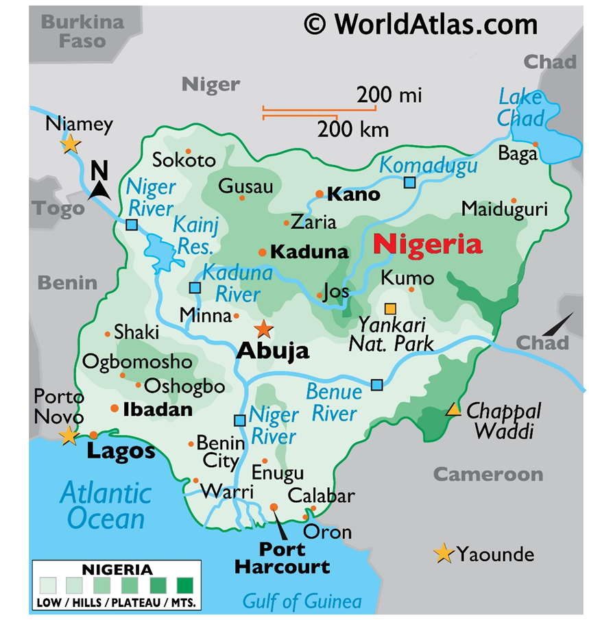
Geographic & Demographic Significance:
- Region: West Africa (Sahelian to Coastal zones)
- Demography: Africa’s most populous country; often termed the “Giant of Africa.”
- Climatic Zones: Exhibits a distinct North-South dichotomy –(Arid/Semi-arid Sahel in the North vs. Humid/Tropical Rainforest in the South.)
Strategic Boundaries & Coastline: –
- West: Benin
- North: Niger
- Northeast: Chad
- East: Cameroon
- Maritime Border: Gulf of Guinea (Atlantic Ocean) in the South.
Administrative & Key Facts: –
- Capital City: Abuja (Centrally located, planned city).
- Economic Hub: Lagos (Former capital, largest metropolitan area).
- Currency: Nigerian Naira (₦).
- Official Language: English (Lingua franca due to colonial history).
Hydrological Features:-
- Major Rivers:
- Niger River: Third longest in Africa (after Nile and Congo); enters Nigeria from the Northwest.
- Benue River: Major tributary; meets the Niger at Lokoja (The Confluence).
- Key Lake: Lake Chad (Endorheic basin in the Northeast; shrinking rapidly due to climate change.
Economic Resource Profile:-
- Energy: Africa’s largest oil producer; member of OPEC.
- Mineral Wealth: Rich in Natural Gas, Tin, Iron Ore, Coal, and Limestone.
International Relations
- Memberships: United Nations (UN), African Union (AU), ECOWAS (Headquarters in Abuja), OPEC, Commonwealth of Nations.
Special Focus: Sokoto State in Nigeria
Geographic & Climatic Features:-
- Location: Extreme Northwest Nigeria; shares a long international border with the Republic of Niger.
- Ecosystem: Situated in the Sudan Savannah and Sahel zones.
- Climate Phenomenon: Heavily influenced by the Harmattan—a dry, dusty trade wind blowing from the Sahara Desert (Nov–March).
- Drainage: Drained by the Sokoto River and Rima River (seasonal tributaries of the Niger River).
Q. With respect to the territorial boundaries of Nigeria, consider the following statements:
1. The country shares its western border with the Republic of Cameroon.
2. Sokoto State shares an international boundary with the Republic of Niger.
3. The southern coastline of Nigeria is bounded by the Gulf of Guinea.

Which of the statements given above is/are correct?
(a) 1 only
(b) 2 and 3 only
(c) 1 and 3 only
(d) 1, 2 and 3

Answer: b

Explanation:
Statement 1 is incorrect: Nigeria shares its western border with Benin, while Cameroon is to the east.
Statement 2 is correct: Sokoto State is located in the extreme northwest and shares a long international border with the Republic of Niger.
Statement 3 is correct: The maritime border to the south is the Gulf of Guinea (Atlantic Ocean).