
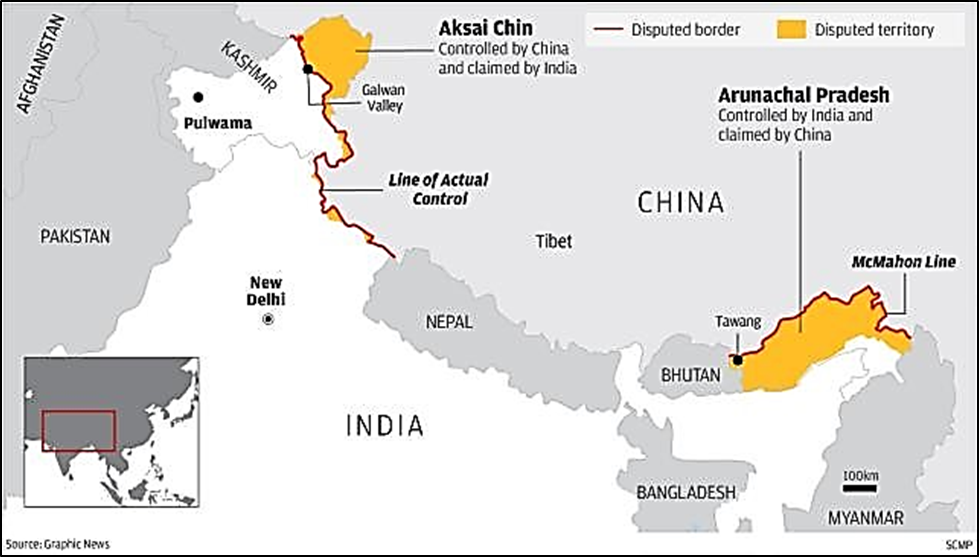
About LAC
- It is the non-demarcated conceptual line separating Indian-controlled and Chinese-controlled territories.
- India perceives the total LAC length to be 3,488 km, whereas China recognizes only ~2,000 km.
- India’s official claim line (includes Aksai Chin and Gilgit-Baltistan) is based on Survey of India maps and differs from the LAC.
- China treats the LAC as its claim line, except in the East where it claims Arunachal Pradesh.
Major Sectors of the LAC
- Western (Ladakh): ~1,597 km; includes friction points like Depsang, Demchok, Galwan, and Pangong Tso.
- Middle (HP & Uttarakhand): ~545 km; least disputed; the only sector where maps were mutually exchanged.
- Eastern (Arunachal & Sikkim): ~1,350 km; follows the 1914 McMahon Line which China rejects.
LAC vs Line of Control (LoC)
- LoC (Pakistan): Emerged from the 1948 ceasefire; formalized by the 1972 Shimla Agreement; legally delineated on signed maps.
- LAC (China): Proposed by China in 1959 and accepted by India in 1993; lacks legal delineation or physical demarcation.
| Key Boundary Lines & Treaties 1897 Johnson-Ardagh Line: Placed Aksai Chin in Jammu & Kashmir; formed the baseline for India’s 1954 maps. 1914 Shimla Accord (McMahon Line): Defined the Eastern border; initialed by China but never ratified. 1993 Peace & Tranquillity Agreement: India accepted the LAC concept to maintain peace without surrendering territorial claims. |
Conclusion
The LAC is a 3,488 km non-demarcated conceptual boundary between India and China, legally distinct from the signed LoC with Pakistan, and managed via bilateral peace agreements pending final settlement.
| This concept has been elaborately discussed in the following article: India–China LAC Talks: Clarifying Perceptions and Managing Border Tensions |