
After Reading This Article You Can Solve This UPSC Mains Model Question:
The choice of a map projection involves a trade-off between geographical accuracy, functional utility and representation. Examine with reference to the Mercator and Equal Earth projections. 15 Marks (GS 2, Polity & Governance)
CONTEXT
- The UN General Assembly adopted a Togo-led resolution, supported by 164 countries, calling for more accurate representation of the world’s land areas, particularly Africa; the US opposed it and six countries abstained.
- The non-binding resolution highlights how the Mercator projection, though useful for navigation, visually exaggerates the size of regions such as Europe and North America relative to Africa and other regions.
INTRODUCTION
The Earth’s curved surface cannot be represented on a flat map without distortions in area, shape, distance or direction. Hence, no projection is perfect—the Mercator–Equal Earth debate highlights the need for purpose-specific and geographically accurate representation.
WHY IS THE MERCATOR PROJECTION BEING QUESTIONED?
1. Inherent Area Distortion: Mercator preserves angles and local shapes, but distorts area increasingly towards the poles. Thus, high-latitude regions appear much larger than their actual size.
2. Misrepresentation of Africa’s Size: Greenland appears comparable to Africa, although Africa is nearly 14 times larger. This can create a misleading perception of continental scale.
3. Eurocentric Representation: Enlargement of Europe and other northern regions has been criticised for reinforcing Eurocentric geographical perceptions. The debate links cartography with colonial legacies, knowledge inequality and Global South representation.
4. Limited Purpose of Mercator: Mercator was designed primarily for navigation, where preserving direction and angles is valuable. It is less suitable for area-based maps, such as population, resources and environmental analysis.
5. Need for Purpose-Specific Projections: Modern cartography requires different projections depending on whether the priority is area, shape, distance or direction. Hence, alternatives like Equal Earth are preferred when accurate relative area is the objective.
EQUAL EARTH: THE ALTERNATIVE
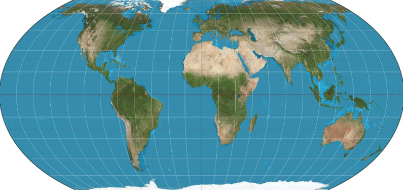
1. Equal-Area Projection: Developed in 2018, Equal Earth is designed to preserve the relative area of landmasses. It reduces the extreme size distortion seen in Mercator, especially at higher latitudes.
2. More Proportionate Representation: Continents such as Africa and South Asia appear closer to their actual relative sizes. This provides a more balanced visual understanding of global geography.
3. Corrects Cognitive Distortion: Helps counter the tendency to underestimate Africa’s actual size created by conventional maps. Strengthens cartographic awareness that maps are representations, not exact replicas of Earth.
4. Useful for Thematic Mapping: Particularly suitable for mapping population, forests, agriculture, minerals, emissions and biodiversity. Accurate area representation makes spatial comparisons more meaningful.
5. Significance for Global South: Challenges inherited Eurocentric representations of geographical space. Highlights the importance of inclusive knowledge systems and balanced global representation.
WHAT IS THE PROBLEM WITH THE NEW MAP?
1. Area Accuracy ≠ Complete Accuracy: Equal Earth corrects area distortion, but still distorts shape, distance and direction. Hence, no single projection can represent all geographical properties accurately.
2. Cannot Completely Replace Mercator: Mercator remains valuable for navigation because constant-bearing routes appear as straight lines. Therefore, replacing it universally would ignore its functional utility.
3. Need for Purpose-Specific Projections: Equal-area projections are better for population, resources and thematic comparisons. Conformal projections like Mercator remain suitable for navigation and certain technical applications.
4. Risk of Treating Cartography as a Political Issue: Criticism of Mercator as “Eurocentric” highlights representation, but its original purpose was primarily navigation. Cartographic reform should therefore remain evidence-based rather than purely political or symbolic.
5. Limited Impact on Global Power Structures: A new map can improve visual representation of the Global South, but cannot by itself correct historical inequalities. Structural issues of knowledge, technology, resources and geopolitical influence require broader reforms.
6. India’s Key Concern: Appropriate and Balanced Adoption: India support projections that provide accurate representation without sacrificing practical utility. The focus is on purpose-specific mapping, rather than a binary choice between Mercator and Equal Earth.
WAY FORWARD
1. Adopt Purpose-Specific Projections: Instead of one universal map, projections should be selected according to the purpose and required geographical property.
- Navigation → Mercator
- Area comparison → Equal-area
- General reference → Compromise projections.
2. Promote Cartographic Literacy: Schools and institutions should explain why maps distort and the strengths and limitations of different projections. This will prevent students from viewing any single map as an absolute representation of geographical reality.
3. Use Equal Earth for Thematic Mapping: Equal-area projections can be increasingly used for population, environment, agriculture, resources and climate mapping. This enables more accurate visual comparison of spatial data, particularly for the Global South.
4. Modernise Digital Cartography: GIS platforms and digital maps should provide projection choices based on the user’s objective rather than defaulting to one conventional projection. This can make digital cartography more scientifically accurate, flexible and context-sensitive.
5. Encourage Diverse Cartographic Perspectives: Mapping should reflect the geographical realities of the Global South without compromising mathematical and scientific accuracy. Greater diversity in cartographic standards can reduce historical representational biases in global geographical understanding.
6. Combine Cartographic Reform with Knowledge Reform: Changing maps must be accompanied by better geographical education, diversified knowledge production and wider Global South representation. Thus, cartographic reform should become part of a broader effort towards epistemic equity and balanced global representation.
CONCLUSION
The Mercator–Equal Earth debate is not about a “wrong” or “correct” map, but about choosing the right projection for the right purpose. The way forward is purpose-specific mapping, cartographic literacy and fair representation to ensure scientifically accurate and cognitively balanced understanding of the world.
| Important Current to Concept From This Article for UPSC Mercator projection |