Context
● Recently, the International Container Transhipment Port (ICTP) at Galathea Bay, Great Nicobar Island, was designated a strategic project by the Ministry of Defence. The ₹81,000-crore project aims to strengthen India’s maritime security in the Indian Ocean, boost transhipment cargo capacity, and counter growing foreign naval influence in the region.
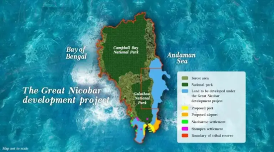
Project Overview and Geography
- Location: Galathea Bay, Great Nicobar Island (Andaman and Nicobar archipelago).
- Project Components: The comprehensive ₹81,000-crore initiative includes the ICTP, a greenfield international airport (for civilian and military use), a township, a gas-powered power plant, and a designated tourism zone.
- Geopolitical Significance: Positioned to capture transhipment cargo currently routed through established hubs like Colombo, Singapore, and Port Klang. It is also viewed as a strategic counterweight to Chinese naval expansion in the Indian Ocean and is influenced by broader security dynamics near the Strait of Hormuz.
Institutional Framework and Implementing Agencies
- ANIIDCO (Andaman and Nicobar Islands Integrated Development Corporation Limited): The nodal proponent for the overall Great Nicobar Island Development Project and the holder of the environmental clearance.
- Kamarajar Port Limited (KPL): The Chennai-based entity acting as the specific implementing agency for the port component (ICTP).
- Public Investment Board (PIB): A Finance Ministry body responsible for appraising large public investments.
- Public-Private Partnership Appraisal Committee (PPPAC): A Finance Ministry body tasked with vetting project proposals worth ₹500 crore and above that involve private sector partnerships.
Major Environmental and Social Concerns
- Threat to Indigenous Tribes: The influx of outsiders threatens the Shompen, an isolated hunter-gatherer community recognized as a Particularly Vulnerable Tribal Group (PVTG).
- Biodiversity Loss: The project requires clearing nearly 130 square kilometers of pristine tropical rainforest. Compensatory afforestation is planned in mainland states like Haryana, which cannot replace the island’s unique ecosystem.
- Marine Ecology: Port construction and dredging at Galathea Bay severely threaten the pristine coral reefs and the globally significant nesting grounds of the endangered Giant Leatherback Sea Turtle.
- Disaster Vulnerability: The island is located in Seismic Zone V (the highest risk category) and is highly prone to mega-earthquakes and tsunamis.
Key Important Facts about Nicobar Islands
- Archipelago Structure: The Nicobar group consists of 22 islands (only 10 are inhabited), forming the southern segment of the Andaman and Nicobar Union Territory in the Bay of Bengal.
- Ten Degree Channel: The critical maritime channel that separates the Andaman Islands (to the north) from the Nicobar Islands (to the south).
- Car Nicobar: The northernmost island of the Nicobar group and its administrative headquarters.
- Great Channel (Six Degree Channel): The international maritime boundary separating Great Nicobar Island (India) from Sumatra (Indonesia).
- Great Nicobar Island: The largest and southernmost island of the Nicobar archipelago. It is heavily forested and recognized as a UNESCO Biosphere Reserve.
- Indira Point: Located on the southern tip of Great Nicobar, it is the southernmost point of India’s territory (formerly known as Pygmalion Point).
- Mount Thullier: The highest peak in the Nicobar group (642 meters), situated on Great Nicobar Island.
- Galathea Bay: A highly sensitive ecological zone on the southeastern coast of Great Nicobar. It is a globally significant nesting site for the Giant Leatherback Sea Turtle.
- Demography: The interior tropical forests are inhabited by the Shompen (a semi-nomadic Particularly Vulnerable Tribal Group), while the coastal areas are home to the Nicobarese (a Scheduled Tribe engaged in agriculture and fishing).
With respect to the geography of the Nicobar archipelago, consider the following statements:
I. The Ten Degree Channel separates the Andaman Islands from the Nicobar Islands.
II. The Great Channel acts as the international maritime boundary separating Great Nicobar Island from Sumatra.
III. Mount Thullier, the highest peak in the Nicobar group, is located on Car Nicobar Island.
How many of the above statements are correct?
A. Only one
B. Only two
C. All three
D. None
Answer: B
Explanation:
Statement I is correct: The Ten Degree Channel is the geographical maritime boundary that separates the Andaman Islands to the north from the Nicobar Islands to the south.
Statement II is correct: The Great Channel, also known as the Six Degree Channel, serves as the international maritime boundary separating India's Great Nicobar Island from Indonesia's Sumatra island.
Statement III is incorrect: Mount Thullier is the highest peak in the Nicobar archipelago, but it is situated on Great Nicobar Island, not Car Nicobar Island.