
Context
- Recently, The UN General Assembly adopted the resolution “Correct the Map: Rebalancing Global Cartographic Representation and Promoting Equitable Representation of the World’s Regions, Particularly Africa” on 4 September 2026.
- The resolution, led by Togo and the African Union, was adopted with 164 votes in favour, 1 against and 6 abstentions. India voted in favour.
What is the issue?
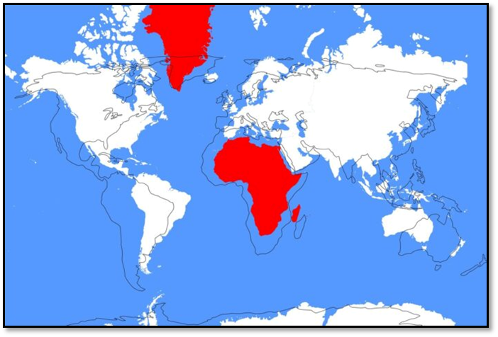
- The initiative seeks to promote world maps that better represent the relative size of continents, particularly correcting the disproportionate visual representation of Africa and other equatorial regions.
The Problem with the Mercator Projection
- The Mercator projection (1569) is a conformal projection designed primarily for navigation.
- It:
- Preserves local angles and direction
- Greatly distorts area, especially towards the poles
- Makes Greenland and other high-latitude regions appear disproportionately large
- Makes equatorial regions such as Africa appear relatively smaller
What Does “Correct the Map” Seek to Change?
- The resolution promotes the wider use of cartographic projections that represent the relative size of continents more accurately.
- It particularly highlights the Equal Earth projection, developed in 2018.
Equal Earth Projection
- Preserves the relative area of continents more accurately.
- Gives a more proportionate visual representation of Africa, South Asia and Latin America
- Parallels are straight horizontal lines, making it easy to compare latitude across different regions.
What Does It Mean for India?
- India supported the resolution.
- However, India also clarified that any cart ographic representation must accurately reflect India’s sovereign territory and official position on its boundaries, including Jammu & Kashmir and Ladakh.
Is the New Map Compulsory?
- The UN resolution is not a legally binding order requiring every country to replace the Mercator projection.
- It encourages governments, educational institutions and other stakeholders to promote more accurate representations of relative continental size.
| Important CTC from this article for UPSC: UN General Assembly |
Q. Consider the following statements regarding the “Correct the Map” resolution and map projections:
1. The Mercator projection preserves area accurately across the globe.
2. The Equal Earth projection is an equal-area projection.
3. No flat map projection can simultaneously preserve area, shape, distance and direction perfectly.
Which of the statements given above is/are correct?
(a) 1 and 2 only
(b) 2 and 3 only
(c) 1 and 3 only
(d) 1, 2 and 3
Answer: B. 2 and 3 only
Statement 1 is Incorrect: The Mercator projection is a conformal projection that preserves local angles and direction, but distorts area, with distortion increasing towards the poles.
Statement 2 is Correct: The Equal Earth projection is an equal-area projection, designed to represent the relative size of continents more accurately.
Statement 3 is Correct: Since the Earth's surface is curved and maps are generally flat, every projection involves some trade-off between area, shape, distance and direction. No single flat projection can preserve all these properties perfectly.