
Important for UPSC Prelims – Geography, Environment & Disaster Management
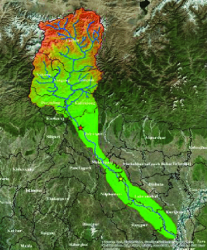
Teesta River Basin (What is it?)
- The Teesta River Basin is a major transboundary river basin of the eastern Himalayas, shared by India and Bangladesh.
- Originating from the Tso Lhamo (Chho Lhamo) Lake in North Sikkim, the river is crucial for hydropower generation, irrigation, drinking water, biodiversity conservation, and regional connectivity.
Course of the River (Where does it flow?)
1. Origin: The Teesta originates from the Tso Lhamo Lake near the Pauhunri Glacier in North Sikkim at an altitude of about 5,300 metres.
2. Course: It flows through Sikkim and West Bengal, carving deep gorges in the Himalayas before entering Bangladesh. The river finally joins the Brahmaputra (Jamuna) in Bangladesh.
3. Length: The total length of the Teesta River is approximately 414 km.
Major Tributaries (Which rivers join the Teesta?)
Left Bank Tributaries
- Rangyong Chu
- Rangpo Chu
- Dik Chu
Right Bank Tributaries
- Rangit River (largest tributary)
- Lachen Chu
- Lachung Chu
Related Government Initiatives
- National Hydroelectric Power Corporation (NHPC): Developing hydropower projects in the Teesta basin with an emphasis on renewable energy generation.
- National Disaster Management Authority (NDMA): Promotes GLOF monitoring, early warning systems, and disaster-resilient infrastructure in Himalayan regions.
- National Mission for Sustaining the Himalayan Ecosystem (NMSHE): Focuses on climate resilience, glacier monitoring, and sustainable development in the Himalayas.
Conclusion
The Teesta River Basin is vital for energy security, ecology, and regional cooperation. Its fragile Himalayan setting demands science-based planning, climate-resilient infrastructure, and sustainable basin-level management.
| This Concept has been Elaborately Discussed in the following Article: Buried Questions: Tunnel Disaster at Teesta Stage-VI |