Context
The government plans to build a new ₹13,000 crore dual-use airport at Galathea Bay in Great Nicobar, citing environmental limits on expanding the existing INS Baaz runway. However, this new project is facing criticism because clearing large areas of protected forest will severely impact the local ecology and the habitat of the vulnerable Shompen tribe.
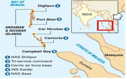
About INS Baaz
- Status & Commissioning: Commissioned in July 2012, it is the southernmost air station of the Indian Armed Forces.
- Geographical Location: Situated at Campbell Bay on Great Nicobar Island (the largest and southernmost island of the Union Territory). It is located in close proximity to Indira Point.
- International Proximity: Located less than 250 km by sea from Banda Aceh, Indonesia.
- Strategic Utility: Operates under the Andaman and Nicobar Command (ANC) to build Maritime Domain Awareness (MDA) via airborne surveillance using aircraft and Unmanned Aerial Vehicles (UAVs).
- Geopolitics: Often described as India’s “window into East and Southeast Asia,” ensuring maritime security across the Bay of Bengal and the Andaman Sea.
Geographical Significance: The Great Channel
- Location: Situated at six degrees north of the equator, earning it the popular name ‘Six Degree Channel’.
- Demarcation: Acts as the critical maritime boundary separating Great Nicobar Island (India) and Aceh Province (Indonesia).
Institutional Setup: Andaman and Nicobar Command (ANC)
- Establishment & Uniqueness: Created in 2001, it holds the distinction of being the first and only tri-service command of the Indian Armed Forces.
- Headquarters: Port Blair, Andaman and Nicobar Islands.
- Primary Objective: Safeguards India’s strategic interests in the critical choke point of the Strait of Malacca and Southeast Asia.
- Operational Role: Provides vital logistical and administrative support for Indian naval ships deployed in the East Asia and Pacific Ocean regions.
With respect to the strategic geography and military infrastructure of the Andaman and Nicobar Islands, consider the following statements:
I. INS Baaz is the southernmost air station of the Indian Armed Forces located at Campbell Bay.
 II. The Six Degree Channel acts as the maritime boundary separating Great Nicobar Island and the Aceh Province of Indonesia.
III. The Andaman and Nicobar Command (ANC) is a dedicated naval-only command established to safeguard India’s interests in Southeast Asia.
Which of the statements given above are correct?
(a) Only I and II
(b) Only II and III
(c) Only I and III
(d) I, II and III
Answer: A
Explanation:
Statement I is correct: INS Baaz is commissioned as the southernmost air station of the Indian Armed Forces and is strategically located at Campbell Bay on Great Nicobar Island.
Statement II is correct: The Great Channel, popularly known as the Six Degree Channel, is the critical maritime boundary that separates Great Nicobar Island of India and the Aceh Province of Indonesia.
Statement III is incorrect: The Andaman and Nicobar Command (ANC), created in 2001, is the first and only tri-service command of the Indian Armed Forces, not a dedicated naval-only command.