
After Reading This Article You Can Solve This UPSC Mains PYQ (2024):
What is the phenomenon of cloudbursts? Explain. 10 marks (GS 3, Disaster Management)
Context
Recent cloudburst-like events in the Himalayas highlight the risks of extreme rainfall, fragile ecology and weak infrastructure. While cloudbursts are natural hazards, unplanned construction, deforestation, poor drainage and weak early warnings amplify their impacts, requiring better forecasting, risk-sensitive planning and resilient infrastructure.
Introduction
According to the IMD, a cloudburst is 10 cm (100 mm) or more rainfall in an hour over about 20–30 sq. km. In mountainous regions, orographic lifting and rugged terrain can trigger flash floods, landslides and debris flows. Thus, the challenge is not only forecasting cloudbursts but also reducing vulnerability and exposure.
Why Are Cloudbursts a Growing Concern for India?
1. Highly Destructive Extreme Rainfall
- Cloudbursts involve an extraordinary concentration of rainfall within a short period and over a small area.The ground cannot absorb such large volumes of water quickly, resulting in rapid runoff, flash floods and landslides.
2. Greater Risk in Mountainous Regions
- Himalayan states such as Uttarakhand, Himachal Pradesh and Jammu & Kashmir are particularly vulnerable.Steep slopes, fragile geology and narrow valleys amplify the impact of intense rainfall.
3. Climate Change Dimension
- A warmer atmosphere can hold more moisture, potentially increasing the intensity of extreme precipitation events.
- Climate change therefore adds uncertainty and may increase the risk of short-duration, high-intensity rainfall.
4. Disaster Risk Beyond Rainfall
- A cloudburst itself is a hazard, but disaster losses depend on exposure and vulnerability.
- Construction on floodplains, deforestation, poor drainage and unplanned infrastructure can significantly magnify damage.
5. Challenge to Weather Forecasting
- Cloudbursts occur over a very small geographical area and develop rapidly.
- Conventional weather models may forecast heavy rainfall for a broad region but struggle to identify the exact location and timing of a cloudburst.
6. Governance and Accountability
- Describing every extreme rainfall disaster as a “cloudburst” can sometimes obscure the role of poor planning, weak infrastructure and inadequate preparedness.
- Scientific attribution is therefore important for ensuring accountability and improving disaster management.
How Does a Cloudburst Form?
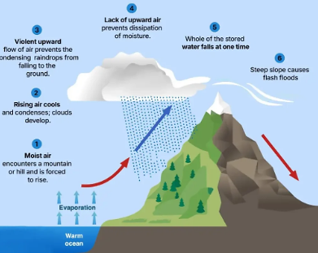
- Moist Air Rises: Moist monsoon winds are forced upward over steep mountains through orographic lifting.
- Cloud Formation: Rising air cools and condenses, producing towering cumulonimbus clouds through intense convection.
- Droplet Accumulation: Strong updrafts hold water droplets until they become too heavy or the updraft weakens.
- Sudden Downpour: Large volumes of water fall rapidly over a small area, triggering flash floods, landslides and debris flows.
Challenges Associated with Cloudbursts & Their Management
- Hyperlocal & Rapid Events – Cloudbursts are highly localised and develop quickly, making precise location- and time-specific forecasting difficult and leaving limited time for evacuation.
- Difficult Himalayan Terrain – Rugged mountains obstruct radar signals, create blind spots and make installation of weather stations and communication networks challenging.
- Sparse Data & Technology Gaps – Remote areas have fewer rain gauges and automatic weather stations, while accurate hyperlocal forecasting requires high-resolution models, dense data and greater computing capacity.
- Weak Last-Mile Early Warning – Even when alerts are generated, poor connectivity and communication gaps may prevent warnings from reaching remote communities, tourists and pilgrims in time.
- Fragile Ecology & Unplanned Development – Deforestation, hill cutting, riverbed construction, poor drainage and unplanned tourism increase runoff, landslides, flash floods and overall disaster vulnerability.
- Inadequate Disaster-Resilient Infrastructure – Weak slope stabilisation, drainage, building standards and hazard-sensitive infrastructure can amplify the damage caused by extreme rainfall.
- Accountability & Risk Management Gap – Treating every disaster as a “cloudburst” can obscure human negligence; hence, disaster management must move from hazard identification to reducing exposure, vulnerability and poor planning.
What Is India Doing to Improve Forecasting and Early Warning?
- Strengthening Nowcasting – IMD is developing short-term forecasting systems to detect rapidly developing thunderstorms, intense rainfall and extreme weather.
- Mission Mausam – Strengthens weather observation, modelling, forecasting and radar networks, with greater use of advanced technologies and AI.
- Expanding Doppler Weather Radars – Wider radar coverage will improve detection of intense rainfall and convective systems, including efforts to reduce Himalayan observation gaps.
- AI & Data Integration – Combining satellite, radar, ground-sensor and numerical-model data can improve hyperlocal forecasting and nowcasting.
- Strengthening Last-Mile Warnings – Alerts should reach vulnerable communities quickly through SMS, mobile alerts, sirens, local administration, community networks and disaster-response agencies.
What Can Be Done to Strengthen Cloudburst Forecasting and Disaster Management?
- Dense Observation & Hyperlocal Forecasting – Expand weather stations and rain gauges; integrate AI, satellite, radar, ground sensors and high-resolution models for location-specific, impact-based warnings.
- Improve Radar & Technology Coverage – Expand Doppler radar networks and adopt complementary technologies to overcome mountainous radar blind spots.
- Strengthen Last-Mile Early Warning – Ensure timely, simple and actionable alerts through mobile messages, sirens, local authorities and trained community volunteers.
- Risk-Sensitive Land-Use Planning – Restrict construction in floodplains, riverbeds, landslide-prone slopes and high-risk valleys, using hazard maps in planning.
- Climate-Resilient & Ecosystem-Based Infrastructure – Improve drainage and slope protection while protecting forests, wetlands and natural drainage channels; avoid unscientific hill cutting and excessive concretisation.
- Scientific Attribution & Accountability – Verify whether rainfall meets the cloudburst threshold and assess the role of poor planning, infrastructure and preparedness, ensuring natural hazards do not mask governance failures.
- Community Resilience & Build Back Better – Train communities in evacuation, first aid and emergency response, while rebuilding damaged infrastructure through safer locations, resilient designs and ecosystem-sensitive planning.
Conclusion
Cloudbursts reflect the rising risk of localised extreme rainfall in a warming climate. India must shift from a hazard-centric to risk-centric approach through better forecasting, early warnings, resilient infrastructure, scientific land-use planning and ecosystem protection.
| Important Current to Concept From This Article for UPSC Cumulonimbus Clouds Mission Mausam |