Context
Recently, India and Brazil signed a series of landmark agreements during the state visit of President Luiz Inácio Lula da Silva to New Delhi. These agreements focus on strategic cooperation in critical minerals (specifically rare earths and lithium), steel mining, and digital public infrastructure.
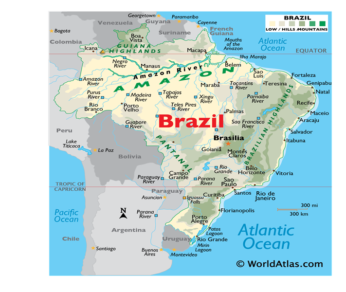
1. Political Location and Borders
- Vast Landmass: Brazil is the fifth-largest country in the world and occupies nearly 47% of the South American continent.
- Latitudinal Extent: It is the only country in the world through which both the Equator and the Tropic of Capricorn pass.
- Neighboring Countries: Brazil shares a border with every South American country except for Chile and Ecuador.
- Coastline: It has an extensive coastline along the Atlantic Ocean to the east.
2. Major Physical Features
- The Amazon Basin (North): This is the world’s largest drainage basin, covered by the Selvas (equatorial rainforests). It is a major carbon sink and is often called the “Lungs of the Earth.”
- The Brazilian Highlands (South-East): This is an ancient plateau composed of old crystalline rocks. It includes sub-ranges like the Serra do Mar and the Serra da Mantiqueira.
- The Pantanal (West): Located primarily in the state of Mato Grosso do Sul, the Pantanal is the world’s largest tropical wetland. It is an internal delta where several rivers converge.
- Mato Grosso Plateau: This is a central upland region that acts as a water divide between the Amazon and La Plata river systems.
3. Drainage Systems
- Amazon River: It originates in the Andes Mountains (Peru) and flows into the Atlantic Ocean. Its major tributaries in Brazil include the Rio Negro (black water) and the Madeira.
- São Francisco River: Known as the “river of national integration,” it is the longest river that runs entirely within Brazilian territory.
- Paraná-Paraguay System: These rivers flow southward and contribute to the Itaipu Dam, one of the world’s largest hydroelectric power producers, shared with Paraguay.
4. Economic Geography & Resources
- The Iron Quadrangle (Quadrilátero Ferrífero): Located in the state of Minas Gerais, this is one of the world’s richest iron-ore mining regions.
- Carajás Mine: Situated in the state of Pará, it is the world’s largest iron ore mine.
- Critical Minerals: Brazil is a global leader in Niobium production and holds significant reserves of Lithium and Graphite, which are vital for India’s EV battery supply chain.
- Agriculture: Brazil is the world’s largest producer of Coffee (grown in “Fazendas”) and a leading producer of Soybeans and Sugar.
Q. Consider the following statements regarding the geography of Brazil:

1. Brazil is the only South American country that shares its border with all other countries of the continent.

2. The São Francisco River is the longest river flowing entirely within the territory of Brazil.

3. The Pantanal, the world’s largest tropical wetland, is located entirely within the Brazilian state of Mato Grosso.

How many of the above statements are correct?

(a) Only one
(b) Only two
(c) All three
(d) None

Solution: (a) Only one

• STATEMENT 1 INCORRECT: While Brazil is vast, it does not share borders with Chile and Ecuador.
• STATEMENT 2 CORRECT: The São Francisco River is indeed the longest river that is entirely Brazilian, originating in Minas Gerais and flowing into the Atlantic.
• STATEMENT 3 INCORRECT: While the majority of the Pantanal is in Brazil (Mato Grosso and Mato Grosso do Sul), it also extends into portions of Bolivia and Paraguay.