Context
Recently, Iran has become a central focus of global geopolitics following significant military escalations in the Middle East. Israeli and U.S. strikes targeted key Iranian strategic locations, including the capital Tehran.
These events have reignited concerns regarding the security of the Strait of Hormuz, a vital global energy chokepoint, and the stability of the International North-South Transport Corridor (INSTC), which connects India to Eurasia via the Iranian port of Chabahar.
1. Political Geography and Borders
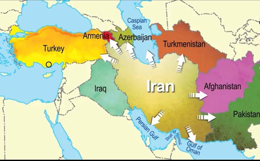
Iran is a West Asian country situated at the crossroads of Central Asia, South Asia, and the Middle East. It shares land borders with seven nations:
- North: Armenia, Azerbaijan, and Turkmenistan.
- East: Afghanistan and Pakistan.
- West: Iraq and Turkey.
- Maritime Borders: The Caspian Sea to the north (shared with Russia, Kazakhstan, Turkmenistan, and Azerbaijan) and the Persian Gulf and Gulf of Oman to the south.
2. Major Mountain Systems
Iran’s topography is dominated by a rugged mountainous rim surrounding a central plateau.
- Alborz Mountains: Located in the north, they run along the southern coast of the Caspian Sea. They house Mount Damavand, a dormant stratovolcano and the highest peak in Iran (approx. 5,671 m).
- Zagros Mountains: This massive fold-and-thrust belt stretches from the northwest (borders with Turkey/Iraq) to the southeast (Strait of Hormuz). It is a major source of Iran’s oil and gas reserves located in its western foothills.
- Kopet Dag: Forms the northeastern border with Turkmenistan.
3. The Central Plateau and Deserts
The interior of Iran consists of the Iranian Plateau, which is largely arid and contains two of the world’s most extreme deserts:
- Dasht-e Kavir (Great Salt Desert): Located in the north-central region, it is characterized by salt marshes and “Kavirs” (salt wastes).
- Dasht-e Lut (Desert of Emptiness): Located in the southeast, it is one of the hottest places on Earth and is a UNESCO World Heritage site known for its spectacular “Yardangs” (wind-sculpted rock formations).
4. Critical Water Bodies and Ports
- Lake Urmia: Situated in the northwest, it is an endorheic (terminal) hypersaline lake. It was once the largest lake in the Middle East but has faced significant shrinking due to drought and damming.
- Strait of Hormuz: A narrow waterway connecting the Persian Gulf to the Gulf of Oman. It is the world’s most important oil chokepoint, through which nearly 20% of global oil consumption passes.
- Chabahar Port: Located on the Makran coast in the Sistan-Baluchistan province (Gulf of Oman). It is strategically vital for India as it bypasses Pakistan to provide a trade route to Afghanistan and Central Asia.
Q. With reference to the geography of West Asia, consider the following statements:

I. The Alborz mountain range forms the natural boundary between Iran and Iraq.

II. Lake Urmia is an endorheic salt lake located in the northwestern part of Iran.

III. The Dasht-e Lut desert is located to the west of the Zagros Mountains.

IV. The Strait of Hormuz connects the Persian Gulf directly to the Arabian Sea.

How many of the above statements are correct?
(a) Only one
(b) Only two
(c) Only three
(d) All four

Answer: A (Only one)

•	Statement 1 Incorrect: The Zagros Mountains follow the western border with Iraq; the Alborz Mountains are in the north along the Caspian Sea.
•	Statement 2 Correct: Lake Urmia is indeed a hypersaline, endorheic lake in the northwest (Azerbaijan provinces of Iran).
•	Statement 3 Incorrect: The Dasht-e Lut is located in southeastern Iran, which is to the east of the Zagros Mountains.
•	Statement 4 Incorrect: The Strait of Hormuz connects the Persian Gulf to the Gulf of Oman; the Gulf of Oman then opens into the Arabian Sea.