After Reading This Article You Can Solve This UPSC PYQ Question:
The frequency of earthquakes appears to have increased in the Indian subcontinent. However, India’s preparedness for mitigating their impact has significant gaps. Discuss various aspects. 2015 (12.5 Marks, GS-3 Disaster Management)
About Earthquakes
An earthquake is the sudden shaking of the Earth’s surface caused by the release of energy in the Earth’s crust, producing seismic waves. It usually occurs along fault lines or tectonic plate boundaries.
- Measured using Richter Scale (magnitude) and Modified Mercalli Intensity (MMI) scale.
- Most earthquakes occur along plate boundaries such as the Pacific Ring of Fire.
- India is highly vulnerable due to its location near the collision zone of the Indian and Eurasian plates.
Causes of Earthquakes
1. Natural Causes
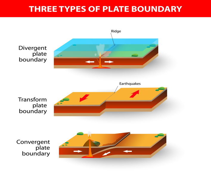
The Earth’s lithosphere is broken into several tectonic plates that are constantly in motion due to convection currents in the mantle.
- Tectonic Movements:
- Convergent Boundaries: Plates collide (e.g., Indian Plate hitting the Eurasian Plate), creating the Himalayas and causing high-magnitude quakes.
- Divergent Boundaries: Plates pull apart (e.g., Mid-Atlantic Ridge), allowing magma to rise and causing tremors.
- Transform Boundaries: Plates slide past each other horizontally (e.g., San Andreas Fault), leading to a buildup and sudden release of friction.
- Volcanic Eruptions: The violent movement of magma or the explosion of gases can trigger localized but intense seismic activity.
- Faulting and Folding: Rocks under immense stress eventually fracture (faulting) or bend (folding). When the elastic limit is exceeded, the “Elastic Rebound Theory” explains the sudden snap that releases seismic energy.
2. Anthropogenic (Human-Induced) Causes
Human activities can alter the stress distribution in the Earth’s crust:
- Reservoir-Induced Seismicity (RIS): The weight of water in massive reservoirs (like the Koyna Dam in Maharashtra) puts pressure on underlying rock layers and can lubricate existing faults.
- Mining and Quarrying: Deep underground mining can cause “rock bursts” or the collapse of mine roofs, triggering tremors.
- Nuclear Explosions: Underground testing of nuclear devices releases a massive amount of energy that mimics a natural earthquake.
Types of Earthquakes
(1) Based on Origin
- Tectonic Earthquakes – caused by plate movements (most common).
- Volcanic Earthquakes – associated with volcanic eruptions.
- Collapse Earthquakes – due to underground mine collapse.
- Explosion-induced Earthquakes – due to nuclear or chemical blasts.
(2) Based on Depth
| Type | Depth | Characteristics |
| Shallow Focus | 0 – 70 km | Most Destructive. Energy has less distance to travel, hitting the surface with high intensity. |
| Intermediate Focus | 70 – 300 km | Moderate impact; often occur at subduction zones. |
| Deep Focus | 300 – 700 km | Also called Plutonic earthquakes. Usually felt over wide areas but cause less surface damage. |
Impact of Earthquakes
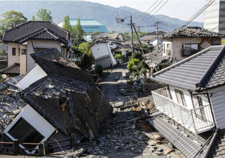
1. Physical & Structural Impacts
- Building Collapse: The primary cause of fatalities.
- Example: 2023 Turkey-Syria Earthquake where “pancake collapses” of thousands of buildings led to over 50,000 deaths.
- Infrastructure Destruction: Damage to “lifeline” infrastructure like bridges, dams, and power grids.
- Example: 1993 Latur Earthquake, which decimated stone-masonry houses in rural Maharashtra.
2. Geological & Environmental Impacts
- Surface Faulting: Visible tearing of the Earth’s crust.
- Liquefaction: Soft soil behaving like liquid, causing buildings to tilt.
- Example: 2011 Niigata (Japan) Earthquake, where entire apartment complexes tilted perfectly intact into the saturated soil.
- Landslides/Avalanches:
- Example: 2015 Nepal Earthquake, which triggered a massive avalanche at the Everest Base Camp and buried the village of Langtang.
3. Secondary Hazards (The “Follow-on” Disasters)
- Tsunamis: Displacement of the ocean floor.
- Example: 2004 Indian Ocean Tsunami (triggered by a Sumatra quake), affecting 14 countries including India’s Andaman & Nicobar Islands.
- Flash Floods: Landslides blocking rivers to create “artificial lakes” that eventually burst.
- Example: Frequent risks in the Sikkim-Himalayan belt following tremors.
- Urban Fires: Ruptured gas lines and electrical short circuits.
- Example: 1923 Great Kanto Earthquake (Japan), where fire caused more deaths than the actual shaking.
4. Socio-Economic Impacts
- Economic Loss: Massive drain on the national exchequer for reconstruction.
- Example: The 2001 Bhuj Earthquake caused an estimated loss of $5 billion and crippled the local handicraft and industrial sectors.
- Public Health Crisis: Outbreak of waterborne diseases in relief camps and long-term PTSD.
- Digital/Communication Blackout: Modern dependency on undersea cables and satellites makes communication fragile.
Earthquake Vulnerability in India
- India lies at the convergent boundary of Indian and Eurasian plates, making the Himalayan belt highly active.
- About 59% of India’s landmass is prone to earthquakes of varying intensity.
- Population at Risk: About 75% of India’s population lives in seismically active regions.
- The “Seismic Gap”: Scientists are particularly concerned about the “Central Himalayan Gap”—a section of the Himalayas that hasn’t seen a major earthquake in over 200 years, making it overdue for a “Great Earthquake” (M > 8.0).
Bureau of Indian Standards (BIS) divides India into four seismic zones (II–V) based on risk.
Approximate distribution:
- Zone V (Very High Risk): Himalayan region, Northeast India, Andaman & Nicobar
- Zone IV (High Risk): Delhi, Kashmir, Himachal Pradesh, Uttarakhand
- Zone III (Moderate Risk): parts of central India
- Zone II (Low Risk): stable peninsular regions
Mitigation Strategies
1. Structural Mitigation (The “Engineering” Fix)
- Seismic Retrofitting: Strengthening older, vulnerable buildings (especially hospitals and schools) using steel bracing, base isolation, or jacketed columns.
- Base Isolation & Dampers: Using flexible bearings or “shock absorbers” at the foundation to decouple the building from ground motion.
- Example: The Bhuj District Hospital was rebuilt with base isolation after the 2001 quake.
- Strict Enforcement of Building Codes: Ensuring all new constructions adhere to IS 1893: 2016 (Seismic Design) and IS 13920 (Ductile Detailing).
- Use of Lightweight Materials: Promoting the use of hollow bricks or Bamboo-based reinforced structures in high-risk hilly terrains (Zone V).
2. Non-Structural Mitigation (The “Policy” Fix)
- Seismic Microzonation: Dividing a city into small “micro-zones” based on soil type to determine which areas will shake more (e.g., Delhi and Bengaluru have completed this).
- Land Use Planning: Prohibiting high-rise construction on “fault lines” or liquefaction-prone riverbeds through strict zoning laws.
- Early Warning Systems (EWS): Installing sensors that detect P-waves (faster, less destructive) to provide a 10–60 second warning before S-waves (destructive) arrive.
- Example: Uttarakhand’s Earthquake Early Warning (EEW) app.
- Capacity Building: Training “Aapda Mitras” (community volunteers) and conducting regular Mega Mock Drills (e.g., Annual ‘Exercise Sahayta’).
3. Institutional & Global Frameworks
- NDMA Guidelines: A shift toward “Safe Construction Practices” and “Mandatory Technical Audits” for high-rise buildings.
- CDRI (Coalition for Disaster Resilient Infrastructure): An Indian-led global initiative to ensure that new infrastructure (power, telecommunications) can withstand seismic shocks.
- Insurance Penetration: Promoting “Catastrophe Insurance” to reduce the fiscal burden on the government post-disaster.
India’s Preparedness on Earthquakes
1. Institutional Framework
- Disaster Management Act, 2005: The bedrock of India’s preparedness, establishing a three-tier structure: NDMA (National), SDMAs (State), and DDMAs (District).
- NDMA Guidelines (2026 Update): The latest guidelines emphasize “Building Back Better” and shifting from generic risk assessment to Probabilistic Seismic Hazard Assessment (PSHA).
- NDRF (National Disaster Response Force): A specialized force with 16 battalions trained in collapsed structure search and rescue (CSSR).
2. Technological & Monitoring Systems
- National Seismological Network (NSN): As of early 2026, the network has expanded to 169 stations (up from 80 in 2014), providing real-time data to the National Center for Seismology.
- Earthquake Early Warning (EEW) Systems: Operational in Uttarakhand (first of its kind in India).
- Research is underway to expand this across the Himalayan Arc to provide a 10–60 second lead time before destructive S-waves hit densely populated plains.
- Sachet Portal (NDMA): A pan-India integrated alert system that uses geo-intelligence to send real-time alerts to mobile phones in local languages.
3. Structural Preparedness (Building Resilience)
- Seismic Microzonation: High-risk cities like Delhi, Bengaluru, Kolkata, and Guwahati have completed microzonation. This allows planners to identify which specific neighborhoods have soil that amplifies shaking (e.g., Yamuna floodplains in Delhi).
- National Building Code (NBC) 2016 & IS Codes: Mandatory standards for seismic-resistant design.
- Retrofitting: Government initiatives to strengthen “lifeline structures” (hospitals, schools, and bridges) in Zone IV and V.
4. Community & Capacity Building
- Aapda Mitra Scheme: A central project that has trained over 1 lakh community volunteers to be “first responders” before professional help arrives.
- School Safety Programs: Conducted by NIDM (National Institute of Disaster Management) to ensure schools in high-risk zones have evacuation plans.
- Traditional Knowledge: Integration of resilient traditional architecture like Kath-Kuni (Himachal) and Dhajji-Dewari (Kashmir) into modern building protocols.
Challenges in Earthquake Management
1. Structural and Engineering Challenges
- Enforcement Deficit: ~80% of buildings in cities like Delhi/Guwahati violate IS 1893 norms; prevalence of “non-engineered” structures built without expert supervision.
- Retrofitting Dilemma: Over 12 crore buildings need strengthening. High costs, technical complexity, and “occupancy disruption” (e.g., inability to vacate hospitals/schools) hinder progress.
- Skill Shortage: Acute lack of licensed structural engineers and masons skilled in ductile detailing and seismic-resistant masonry.
2. Institutional and Policy Challenges
- The 2026 “Seismic Rollback”: The recent withdrawal of the IS 1893: 2025 code (which proposed ‘Zone VI’) due to industry pushback.
- Reason: Concerns over 20–50% spike in construction costs and the risk of “stranded assets” in infrastructure.
- Top-Down Governance: Over-centralization persists; DDMAs (Districts) lack independent budgets and technical staff to implement microzonation data.
- Connectivity Gaps: Despite 169 monitoring stations, India lacks “last-mile connectivity” for real-time Early Warning Systems (EWS) in the Indo-Gangetic plains.
3. Geographical and Socio-Economic Challenges
- Himalayan Fragility: Tectonic stress in the “Central Himalayan Gap” makes the region overdue for an M > 8.0 quake; compounded by unplanned hill urbanization.
- Soil Amplification & Liquefaction: Soft alluvial soil in the North Indian plains amplifies tremors and causes ground failure (liquefaction) far from the epicenter.
- Rural-Urban Divide: Rural reliance on “Kutcha” masonry leads to “pancake collapses,” while urban density increases the risk of secondary hazards like fires.
Way Forward
- Risk-Informed Governance: Transition from the 2026 Seismic Rollback to a phased implementation of IS 1893:2025 standards, mandating “Seismic Compliance Certificates” for all lifeline infrastructure (Metros, Nuclear Plants, Hospitals) first.
- National Retrofitting Mission: Address the vulnerability of 12 crore existing structures through a dedicated mission providing “Resilience Loans,” tax rebates, and Parametric Insurance to ensure immediate liquidity post-event.
- Technological Last-Mile Connectivity: Scale the Himalayan Early Warning System (EEW) to enable automated triggers for shutting down gas grids and rail networks, while integrating Seismic Microzonation into Smart City Master Plans.
- Decentralized Capacity Building: Expand the Aapda Mitra program to every district and bridge the technical “Skill Gap” by certifying local masons in ductile detailing and resilient traditional styles like Kath-Kuni.
- Mainstreaming DRI: Utilize the Coalition for Disaster Resilient Infrastructure (CDRI) to “disaster-proof” the National Infrastructure Pipeline (NIP), shifting the paradigm from “Reactive Relief” to “Proactive Risk-Informed Development.”
Conclusion
Moving from a “Reactive Relief” to a “Risk-Informed Development” paradigm is vital. Integrating the Sendai Framework with cutting-edge Early Warning Systems and CDRI leadership will ensure India’s $5 trillion economic vision remains resilient against seismic uncertainties.