Context
The Union government is fast-tracking a ₹92,000 crore mega-infrastructure project to transform Great Nicobar Island into a major port and tourism-led economy. The project is strategically positioned to leverage the island’s location at the western entrance of the Malacca Strait.
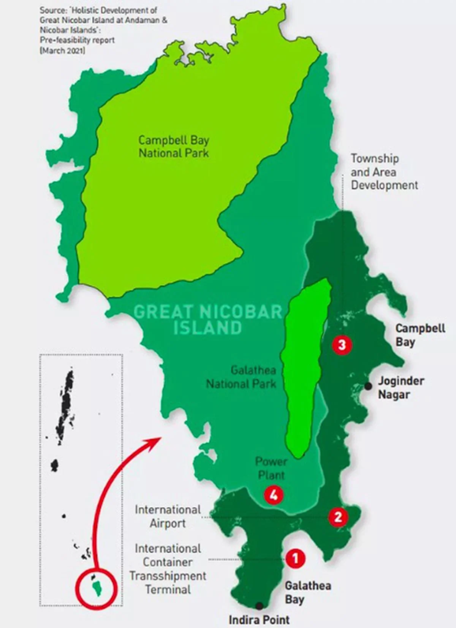
1. Key Components of the Project
- International Container Transshipment Port (ICTP): Aimed at capturing a significant share of global sea trade.
- Greenfield International Airport: To support both tourism and logistics.
- Power Plant: To provide necessary energy infrastructure for the planned urban center.
- Township/Social Infrastructure: Envisions healthcare, education, and biodiversity tourism facilities.
- Target Demographics: A projected population of 3.36 lakh by 2055, with an expected tourist inflow of one million annually.
- Promoting Body: NITI Aayog
- Implementing Agency: Andaman and Nicobar Islands Integrated Development Corporation Limited (ANIIDCO)
- ANIIDCO was incorporated on 28th June 1988 under the Companies Act 1956 for rapid economic growth of the Islands.
- Operates under: Ministry of Home Affairs
2. Geographical and Strategic Significance
- Location: Great Nicobar is the southernmost island of the Andaman and Nicobar archipelago.
- Maritime Importance: Its proximity to the Malacca Strait is vital for India’s maritime security and economic interests in the Indo-Pacific region.
- Economic Goal: To facilitate transshipment, reducing India’s dependence on foreign ports like Colombo or Singapore.
3. Indigenous Groups and Social Concerns
The project impacts two primary Particularly Vulnerable Tribal Groups (PVTGs) and local indigenous communities:
- The Shompen: A nomadic hunter-gatherer tribe living in the interior forests of GNI.
- The Nicobarese: An indigenous community primarily residing along the coasts.
- Rights Issues: Concerns regarding the settlement of forest rights and the potential relocation of these communities to make way for infrastructure.
4. About Andaman and Nicobar Islands (ANI)
- ANI is a UT with 572 islands (Bay of Bengal), of which 38 are inhabited.
- Comprises two groups: Andaman Islands and Nicobar Islands, divided by the10° Channel.
- Duncan Passage separates Little Andaman from South Andaman.

Closer to equator: Located between 6° to 14°
Separated from Thailand and Myanmar by the Andaman Sea.
- Island chain is a submerged extension of the Arakan Mountains.Dugong (sea mammal) is the official animal, endemic to the Indo-Pacific coast, especially Andaman.
- In 2018, three islands were renamed to honour Subhas Chandra Bose:
- Ross → Netaji Subhash Chandra Bose Island
- Neil → Shaheed Island
- Havelock → Swaraj Island
- In September 2024, the capital of the ANI (Port Blair) was renamed Sri Vijaya Puram.
5. Hotspot Status and biodiversity:
- Nicobar fall under the Sundaland Biodiversity Hotspot.
- Great Nicobar Biosphere Reserve: It covers 885 km² across Campbell Bay and Galathea National Parks (core zone).
Consider the following statements with reference to the Great Nicobar Island (GNI) Project:

1. The Great Nicobar Project, initiated by Ministry of Ports, Shipping and Waterways, aims to leverage the island’s strategic location near the Malacca Strait.

2. The core components of the GNI Project include; an International Container Transshipment Terminal (ICTT), a dual-use military civilian airbase, and a mega solar–gas hybrid power plant.

3. Galathea Bay, included in the project region, is a nesting site of the Leatherback turtle.

Which of the above statements is/are correct?
a) 1 only
b) 1 and 2 only
c) 2 and 3 only
d) 3 only

Answer: C

Explanation:
• The Great Nicobar Island (GNI) Development project, officially named the "Holistic Development of Great Nicobar Island," is a massive infrastructure plan spearheaded by NITI Aayog and executed by the Andaman and Nicobar Islands Integrated Development Corporation (ANIIDCO). So, statement 1 is not correct.

• The Great Nicobar Island Development Project includes an International Container Transshipment Terminal (ICTT), a greenfield international airport, two greenfield cities, a coastal mass rapid transit system, and a free trade zone. So, statement 2 is correct.

• Key concerns: Great Nicobar, over 85% rainforest-covered, is a biodiversity hotspot; Galathea Bay, a Ramsar wetland, is a key nesting site for endangered Leatherback turtles. So,statement 3 is correct.