Context
- Recently, Nepal’s Prime Minister Balendra Shah stated in Parliament on Sunday that Nepal too has encroached upon Indian territories in many places. This statement, marking the first time a Nepalese head of government has made such an admission, was delivered in response to a lawmaker’s query regarding the disputed Kalapani region and triggered a significant political uproar from opposition parties like the Nepali Congress and the Nepali Communist Party.
- The long-standing boundary dispute over Lipulekh, Limpiyadhura, and Kalapani recently resurfaced after India announced the revival of the Kailash Mansarovar Yatra pilgrimage via the Lipulekh route, prompting Nepal to send diplomatic notes to both India and China, while India maintains that these territories are an integral part of Uttarakhand.
Historical Genesis of the Border
- The Treaty of Sugauli (1816): This treaty was signed between the Kingdom of Nepal and the British East India Company following the Anglo-Nepalese War of 1814–1816, establishing the modern territorial limits of Nepal.
- Border Rivers: The treaty designated the Kali River (Mahakali) as Nepal’s western boundary with India and the Mechi River as its eastern boundary.
- The Root Cause: The treaty text did not include a definitive map or clarify the exact geographic source of the Kali River, creating room for conflicting cartographic interpretations.
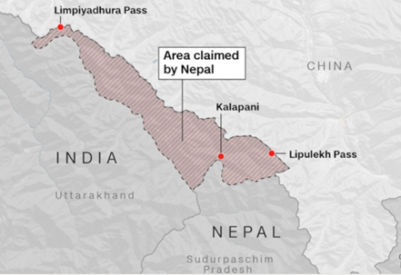
Major Disputed Sectors
1. The Northwestern Tri-Junction (Kalapani, Lipulekh, Limpiyadhura)
- Limpiyadhura: Nepal claims the Kali River originates further northwest at Limpiyadhura, asserting that all land east of this stream belongs to it.
- Kalapani: India maintains the river originates from a different set of springs at Kalapani, placing the border along the ridge line east of the springs.
- Lipulekh Pass: This strategic high-altitude pass is controlled by India and serves as a vital trade and pilgrimage route to Tibet, but it is claimed by Nepal as part of its territory.
2. The Susta Sector
- The Location: Susta is situated in the southern Terai plains along the border between Bihar and Nepal.
- The Dispute: The boundary was originally defined by the course of the Gandak River (Narayani). Over the decades, the river shifted its course southward due to flooding, leading to conflicting claims over the newly exposed lands.
Divergent Positions of India and Nepal
- Nepal’s Stance: Kathmandu relies strictly on the text of the 1816 Treaty of Sugauli. In 2020, Nepal passed a constitutional amendment adopting a new political map that includes Kalapani, Lipulekh, and Limpiyadhura within its borders.
- India’s Stance: New Delhi relies on British administrative survey maps drawn after 1860, which depict Kalapani within Indian territory. India maintains continuous administrative control and security presence in the region and rejects unilateral cartographic changes.
Mechanisms for Resolution
- Joint Technical Level Boundary Committee (JTB): This body successfully mapped and agreed upon nearly 97% of the 1,850 km border, leaving only Kalapani and Susta unresolved.
- Fixed Boundary Principle: To counter the shifting nature of the Gandak and Mechi rivers, both nations agreed to lock the boundary at fixed geographic coordinates based on historical surveys, ensuring river migration does not alter sovereign titles.
Q. Consider the following statements regarding the boundary alignment between India and Nepal:
STATEMENT I: The Treaty of Sugauli, signed in 1816 between the Kingdom of Nepal and British India, established the Kali River as the natural western boundary of Nepal.
STATEMENT II: The recent territorial dispute over the Susta sector in the southern plains is primarily caused by the shifting course of the Mechi River over several decades.
Which one of the following is correct in respect of the above statements?
(a) Both Statement I and Statement II are correct and Statement II is the correct explanation for Statement I
(b) Both Statement I and Statement II are correct and Statement II is not the correct explanation for Statement I
(c) Statement I is correct but Statement II is incorrect
(d) Statement I is incorrect but Statement II is correct
Solution & Explanation
Correct Answer: (c)
• STATEMENT I IS CORRECT: The 1816 Treaty of Sugauli officially concluded the Anglo-Nepalese War and designated the Kali River as the western international boundary of Nepal, separating it from India's Kumaon region.
• STATEMENT II IS INCORRECT: The territorial dispute in the Susta sector is caused by the changing course of the Gandak River (also known as the Narayani River), not the Mechi River. The Mechi River defines a portion of the eastern border of Nepal, whereas Susta lies in the south adjacent to Bihar.