
After Reading This Article You Can Solve This UPSC Mains Model Question:
“Climate change has transformed floods in Assam from seasonal events into recurrent extreme disasters.” Discuss the causes, impacts and suggest measures to enhance flood resilience. (10 marks, GS3 Environment Ecology and Disaster management)
Why is in news
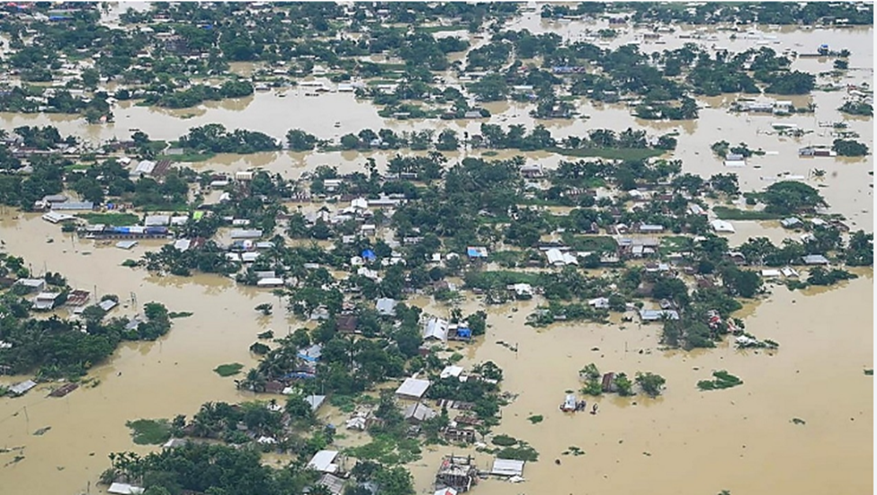
Within a short span, Assam experienced one of its worst flood disasters in recent years, affecting over 16 lakh people, inundating thousands of villages, damaging infrastructure, and triggering landslides across northeastern states. Experts attribute the severity to an interaction between climate change-induced extreme rainfall events and local ecological degradation.
Introduction
- Floods are a recurring natural phenomenon in Assam due to the Brahmaputra and Barak river systems. However, the floods witnessed in 2026 are unprecedented because of the combined effects of extreme rainfall, climate change, geographical vulnerability, and increasing human-induced environmental degradation.
- The disaster demonstrates how climate change is intensifying hydro-meteorological disasters, making traditional flood management strategies inadequate.
Reason behind Assam’s frequent occurence of unprecedented flooding?
1. Climate Change-Induced Extreme Rainfall (Primary Factor)
- Rising global temperatures have increased the atmosphere’s moisture-holding capacity (approximately 7% more moisture per 1°C warming according to the Clausius-Clapeyron relationship).
- This results in:
- Short-duration, high-intensity rainfall.
- Cloudburst-like events.
- More frequent extreme precipitation.
- Instead of gradual rainfall, Assam is receiving very heavy rain within a few hours, overwhelming rivers and drainage systems.
2. Climate Change Intensifying the Indian Monsoon
Climate change has made the Southwest Monsoon increasingly erratic.
Features include:
- Delayed onset, long dry spells
- Sudden intense rainfall and localized extreme weather events
Such rainfall rapidly increases river discharge, leading to flash floods.
3. Geographic Vulnerability of Assam
Assam’s physical geography naturally makes it flood-prone.
a) Brahmaputra River System
- One of the world’s largest braided rivers.
- Receives enormous discharge from Tibet, Arunachal Pradesh, Meghalaya,Bhutan
- Heavy rainfall across the entire basin causes sudden rise in water level.
b) Low-Lying Floodplains
Much of Assam lies within the floodplains of the Brahmaputra, making settlements highly vulnerable.
c) High Sediment Load
- The Brahmaputra carries one of the world’s highest sediment loads due to Young Himalayan geology,Soil erosion, Landslides
- Sediment deposition raises riverbeds and reduces water-carrying capacity.
4. Cloudburst and Orographic Rainfall
- Moisture-laden monsoon winds strike the hills of Meghalaya, Arunachal Pradesh, Nagaland.
- This causes Orographic lifting,Cloudbursts,Extremely intense localized rainfall the runoff eventually enters Assam’s river system.
5. Simultaneous Rainfall Across Entire River Basin
- Experts note that rainfall occurred simultaneously in Assam, Arunachal Pradesh, Meghalaya and Bhutan
- This synchronized rainfall caused all tributaries to swell together, dramatically increasing the Brahmaputra’s discharge.
6. Deforestation and Forest Degradation
- Loss of forests has reduced the land’s capacity to absorb rainwater consequences include increased surface runoff, soil erosion, landslidesand rapid river swelling
- Forests act as natural sponges that delay runoff.
7. Wetland and Floodplain Encroachment
- Important wetlands have been degraded due to Urban expansion, Illegal settlements, Infrastructure development
- Loss of wetlands has reduced the natural storage capacity for excess floodwater.
8. Unplanned Urbanisation
- Cities such as Guwahati face severe urban flooding because of Encroached drainage channels, Concretization, Blocked storm-water drains, Poor land-use planning.
9. Riverbank Erosion
- The Brahmaputra experiences severe bank erosion every year.Effects include Widening of river channels, Loss of agricultural land, Displacement of communities, Increased sediment deposition
Challenges of Extreme Weather Events
1. Increasing Frequency and Intensity
- Events like Heatwaves Floods, Cyclones, Cloudbursts, Landslides, Glacial Lake Outburst Floods (glofs) are becoming more frequent.
2. Forecasting Challenges
- Highly localized rainfall is difficult to predict.
- Existing forecasting models have limitations in mountainous terrain.
3. Inadequate Urban Infrastructure
- Because of Poor drainage, Encroachment, Weak disaster-resilient infrastructure increase vulnerability.
4. Ecological Degradation
- Deforestation, Wetland destruction, River pollution, Sand mining reduce ecosystem resilience.
5. Disaster Preparedness Gap
- Many vulnerable regions still lack Early warning dissemination, Community awareness, Evacuation infrastructure, Disaster-resilient housing.
7. Climate Adaptation Deficit
Development planning has not fully integrated climate risk assessments.
Impact of the Floods
A. Environmental Impact
- Massive soil erosion Riverbank collapse, Wetland degradation, Biodiversity loss, Habitat destruction in Kaziranga and other protected areas, Increased landslides, Water contamination.
B. Social Impact
- Large-scale displacement andLoss of human lives
- Food insecurity due to crop loss.
- Health emergencies and Spread of water-borne diseases.
C. Economic Impact
- Crop destruction and Livestock losses
- Damage to roads and bridges,Railway disruption cause infrastructural issues.
D. Governance Challenges
- Difficult rescue operations, Relief distribution in inaccessible areas, Rehabilitation of displaced populations and Coordination among multiple agencies
Government Initiatives
1. National Disaster Management Authority (NDMA)
- National Guidelines on Flood Management
- Capacity building programme
- Community-based disaster management
2. National Disaster Response Force (NDRF)
- Search and rescue and Medical assistance during disaster response operation.
- Relief operations and Evacuation during floods and precautions for after effects
3. India Meteorological Department (IMD)
- Impact-based weather forecasting
- Doppler Weather Radars incorporation for heavy rainfall warnings
- Lightning alerts awareness
4. Central Water Commission (CWC)
- Flood forecasting stations, River-level monitoring in regular basis
- Reservoir management support, Real-time flood alerts
5. Flood Management and Border Areas Programme (FMBAP)
- Embankments, Anti-erosion measures
- Drainage improvement, River training works
6. National Hydrology Project
- Real-time hydrological data, Improved flood forecasting
- Basin-level water management
7. National Action Plan on Climate Change (NAPCC)
Relevant missions include:
- National Water Mission, Green India Mission
- Sustainable Agriculture Mission
These enhance climate resilience and ecosystem restoration.
8. Sendai Framework for Disaster Risk Reduction (2015–2030)
India aligns its disaster management strategy with the Sendai Framework, focusing on:
- Risk reduction, Preparedness, Build Back Better and Resilience
9. State-Level Measures in Assam
- SDRF deployment and settibn up Evacuation camps
- Boat rescue operations
- Relief distribution
- Early warning dissemination
- Embankment strengthening
Way Forward
1. Shift from Flood Control to Flood Risk Management
- Adopt Integrated River Basin Management (IRBM) for the Brahmaputra basin involving India, Bhutan, and China for coordinated data sharing and basin planning.
2. Nature-Based Solutions
- Restore wetlands and floodplains as natural water buffers.
- Large-scale afforestation in upstream catchments.
- Protect riparian vegetation to reduce erosion.
3. Climate-Resilient Infrastructure
- Build elevated roads, bridges, schools, and health centres.
- Develop flood-resilient housing in vulnerable districts.
4. Strengthen Early Warning Systems
- Expand Doppler Weather Radar coverage.
- Use AI, satellite imagery, GIS, and IoT-based river monitoring.
- Improve last-mile dissemination through mobile alerts and community volunteers.
5. Scientific Land-Use Planning
- Restrict construction in floodplains.
- Enforce zoning regulations and prevent encroachment on wetlands and drainage channels.
6. Improve Urban Flood Management
- Upgrade storm-water drainage.
- Promote permeable surfaces and rainwater harvesting.
- Restore urban water bodies.
7. Ecosystem Restoration
- Conserve forests in the Eastern Himalayas.
- Control illegal sand mining.
- Implement catchment area treatment programmes.
8. Community-Based Disaster Risk Reduction
- Train local communities in evacuation and first response.
- Strengthen village disaster management committees.
- Promote flood insurance and resilient livelihoods.
Conclusion
- The unprecedented floods in Assam underscore the growing reality of climate-induced hydro-meteorological disasters, where natural vulnerabilities are amplified by environmental degradation and unsustainable development.
- Addressing this challenge requires a paradigm shift from reactive relief to anticipatory, ecosystem-based, and climate-resilient disaster management.
- By integrating scientific forecasting, sustainable river basin management, nature-based solutions, resilient infrastructure, and community participation, India can significantly reduce disaster risk while advancing the goals of disaster resilience, climate adaptation, and sustainable development—a necessity for achieving the vision of Viksit Bharat 2047.
| Important CTC covered under this article are Brahmaputra river Cloud burst |