
Context
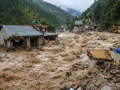
- Heavy rainfall triggered flash floods in the Poonch and Rajouri districts of Jammu & Kashmir, resulting in multiple fatalities, injuries, and widespread damage to houses, schools, roads, and other public infrastructure. The incident highlights the increasing vulnerability of the Himalayan region to extreme weather events.
What are Flash Floods?
- Flash floods are sudden floods that develop within a few minutes to a few hours after intense rainfall, cloudbursts, dam failure, or rapid snow/glacier melt.
- They are characterized by:
- Very rapid rise in water level.
- High velocity of water flow.
- Little or no warning time.
- Severe damage to life and property.
Why is Jammu & Kashmir Vulnerable to Flash Floods?
1. Fragile Himalayan Terrain
- Young fold mountains with unstable slopes.
- Highly prone to landslides and soil erosion.
2. Intense Rainfall & Cloudbursts
- Localized heavy rainfall causes sudden runoff.
- Small mountain streams overflow rapidly.
3. Steep River Gradients
- Rivers descend rapidly from high elevations.
- Water flows with high speed, increasing flood intensity.
4. Unplanned Development
- Construction along riverbanks and floodplains.
- Encroachment of natural drainage channels.
5. Climate Change
- Increasing frequency of extreme rainfall events.
- Rapid glacier melt adds to flood risk.
Major Rivers of Jammu & Kashmir
| River | Origin | Important Facts |
| Jhelum | Verinag Spring | Lifeline of Kashmir Valley; tributary of the Indus |
| Chenab | Confluence of Chandra & Bhaga rivers | Major hydropower river |
| Ravi | Himalayas (Himachal Pradesh) | Forms part of J&K’s southern drainage |
| Tawi | Kailash Kund | Flows through Jammu city |
| Poonch River | Pir Panjal Range | Tributary of the Jhelum |
Previous Major Flood Events in Jammu & Kashmir
- 2014 Kashmir Floods – One of the worst floods in the region; widespread inundation of Srinagar due to overflowing Jhelum River.
Frequent flash floods and landslides occur during the southwest monsoon and western disturbance-induced rainfall.
Institutional Framework
- National Disaster Management Authority (NDMA) – Apex disaster management body.
- National Disaster Response Force (NDRF) – Specialized disaster response force.
- India Meteorological Department (IMD) – Weather forecasting and early warnings.
- State Disaster Management Authority (SDMA) – State-level disaster planning and response.
Consider the following pairs:
River	                         Major Basin System
1. Poonch River	              Jhelum River Basin
2. Ansi River	             Chenab River Basin
3. Rajouri Tawi	             Ravi River Basin
How many of the above pairs are correctly matched?
(a) Only one
(b) Only two
(c) All three
(d) None
Answer: (b) Only two
• Pair 1 is correct: The Poonch River originates in the Pir Panjal Range and joins the Jhelum River.
• Pair 2 is correct: The Ansi River drains parts of the Budhal area in Rajouri and flows into the Chenab basin.
• Pair 3 is incorrect: Rajouri Tawi (also called Naushera Tawi) feeds into the Chenab river network, not the Ravi River.