
Why in News?
- The ongoing conflict between the Sudanese Armed Forces (SAF) and the paramilitary Rapid Support Forces (RSF), which erupted in April 2023, has severely intensified.
- According to a UNICEF report, active warfare and drone strikes are heavily concentrated in the Kordofan, Darfur, and Blue Nile states of Sudan, leading to massive civilian casualties and acute humanitarian crises.
Key Geographical & Strategic Insights
1. Darfur Region
- Location & Borders: Located in western Sudan, it shares international borders with Chad, the Central African Republic, and Libya.
- Topography: Features the Jabal Marrah, a volcanic massif towering 900 meters above the Sudanic plain. The drainage from this massif supports a settled population, contrasting with the northern and eastern parts of Darfur which are hyper-arid or semi-deserts.
- Significance: Darfur has historically faced prolonged ethnic conflicts, including the 2003 war which targeted non-Arab indigenous populations such as the Fur, Zaghawa, and Masalit peoples.
2. Kordofan Region
- Location: Situated in the central-southern belt of Sudan, it is administratively split into North, South, and West Kordofan states.
- Topography: Dominated by the Nuba Mountains in South Kordofan, which are home to the indigenous Nuba peoples.
- Resource Profile: West Kordofan hosts critical oilfields that are essential to Sudan’s economic infrastructure, rendering it a highly contested zone.
- Water Scarcity: The region lacks perennial streams, meaning both populations and livestock are heavily dependent on permanent wells and groundwater.
3. Blue Nile State
- Location: Positioned in the southeastern corner of Sudan, bordering Ethiopia and South Sudan.
- The Blue Nile River: The state is named after the river that originates in Lake Tana (Ethiopia). It flows through this region before merging with the White Nile at Khartoum to form the main Nile River.
- Economic/Strategic Value: The region encompasses the Roseires Dam, a critical reservoir used for generating hydroelectric power and managing agricultural irrigation along the fertile clay plains of central Sudan.
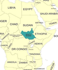
| Geographic Profile of Sudan Borders: It is a Northeast African nation bordered by seven countries: Egypt (North), Libya (Northwest), Chad (West), Central African Republic (Southwest), South Sudan (South), Ethiopia (Southeast), and Eritrea (East). Maritime Access: Its eastern coastline opens up to the Red Sea, hosting the vital maritime trade hub of Port Sudan. Major Drainage: The Nile Basin covers the vast majority of its area, driven by the confluence of the White Nile (from Uganda) and the Blue Nile (from Ethiopia) meeting at the capital city, Khartoum. |
Q. Consider the following pairs:
Region in News	        Country
1. Darfur	        Sudan
2. Kordofan	        Ethiopia
3. Blue Nile	        South Sudan
How many of the pairs given above are correctly matched?
(a) Only one pair
(b) Only two pairs
(c) All three pairs
(d) None of the pairs
Answer: (a)
• Explanation: Only Pair 1 is correctly matched. Darfur is in western Sudan. Kordofan is a region in central-southern Sudan (not Ethiopia). Blue Nile is a state located in southeastern Sudan (not South Sudan).