Context
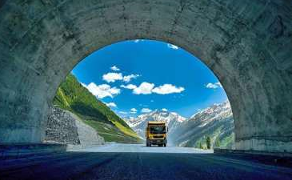
- Recently, the strategically important Zojila Tunnel achieved its final excavation breakthrough. Built by Megha Engineering and Infrastructures Ltd., this major milestone brings India closer to establishing an all-weather road link to the border regions, ensuring year-round connectivity between Kashmir and Ladakh.
1. About the Zojila Tunnel
- Geographic Alignment: The tunnel spans 13.14 km (main tunnel length is approx. 13.15 km) under the treacherous Zoji La Pass on National Highway 1 (NH-1). It directly connects the Ganderbal district (Sonamarg/Baltal) of Kashmir with the Dras/Kargil district (Minimarg) of Ladakh.
- Key Dimensions: It is a horseshoe-shaped, single-tube, two-lane bi-directional road tunnel constructed at an extreme altitude of approximately 11,578 feet above sea level. This makes it one of the longest high-altitude, single-tube bi-directional road tunnels globally.
- Engineering Standard: Built using the New Austrian Tunnelling Method (NATM) to successfully mitigate the challenges of volatile seismic activity (Seismic Zone IV) and unstable, fragile Himalayan rock formations.
- Core Significance:
- All-Weather Connectivity: Historically, the Zoji La Pass remains completely choked by heavy snowfall and avalanches for 3 to 6 months in winter, severing Ladakh’s land link with the rest of India. The tunnel eliminates this seasonal isolation.
- Drastic Time Reduction: It slashes the treacherous commute time across the pass from 3 hours down to just 15–20 minutes.
2. Strategic Implication: The Line of Actual Control (LAC)
The Line of Actual Control (LAC) is the effective, non-demarcated border that separates Indian-controlled territory from Chinese-controlled territory (primarily across Ladakh, Uttarakhand, Himachal Pradesh, Sikkim, and Arunachal Pradesh).
- Year-Round Logistics: Eliminates the need for massive winter stockpiling of rations, fuel, and ammunition in Ladakh.
- Rapid Military Deployment: Ensures all-weather movement of troops, tanks, heavy equipment, and supplies to forward areas along the LAC.
- Enhanced National Security: Strengthens India’s preparedness against threats from both Pakistan and China by maintaining uninterrupted military mobility.
3. Other Strategic Tunnels and Passes in the Region
To secure border logistics, India has created a vast web of high-altitude bypass networks:
| Infrastructure | State / UT |
| Z-Morh Tunnel | Jammu & Kashmir |
| Atal Tunnel | Himachal Pradesh |
| Sela Tunnel | Arunachal Pradesh |
| Dr. Syama Prasad Mookerjee Tunnel | Jammu & Kashmir |
| Banihal-Qazigund Road Tunnel | Jammu & Kashmir |
Consider the following pairs:
         Tunnel	                           State / UT
1.     Atal Tunnel	                   Himachal Pradesh
2.     Sela Tunnel	                   Arunachal Pradesh
3.     Z-Morh Tunnel	                   Jammu & Kashmir
4.     Banihal-Qazigund Road               Tunnel Uttarakhand
How many pairs given above are correctly matched?
(a) Only one
(b) Only two
(c) Only three
(d) All four
Answer: C
Explanation:
The Banihal-Qazigund Road Tunnel is located in Jammu and Kashmir, not Uttarakhand.
Therefore, 3 pairs are correctly matched.