
After Reading This Article You Can Solve This UPSC Mains Model Question:
“Climate change is transforming the Himalayan region’s natural hazards into compound and cascading disasters.” Discuss the major vulnerabilities of the Himalayas and suggest measures for building disaster-resilient development. 15 Marks (GS 3, Disaster Management)
CONTEXT
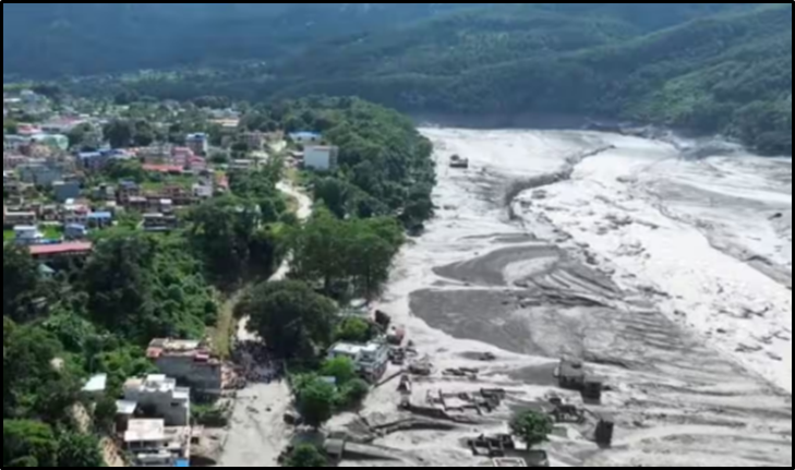
- Nepal flash flood: Possible glacier/ice-rock collapse in Tibet → river blockage → sudden release, causing severe flooding. Highlights rising compound & cascading Himalayan disasters amid climate change.
- Sikkim GLOF (2023): South Lhonak Lake outburst caused major infrastructure and hydropower damage.
INTRODUCTION
The Himalayas, a young and fragile mountain system, are increasingly vulnerable to climate change and extreme events. Natural hazards like GLOFs, flash floods and landslides are being amplified by warming and unplanned development, making risk reduction and vulnerability management the key priority.
BACKGROUND & MAGNITUDE OF THE CHALLENGE
A. Increasing Cryospheric Vulnerability
1. Glacier Melting and Retreat: Rising temperatures accelerate glacier melting, causing glaciers to lose mass and retreat. This alters river flows and increases the formation of unstable water bodies in high-altitude regions.
2. Formation and Expansion of Glacial Lakes: Meltwater accumulates behind natural barriers such as moraines, forming glacial lakes. Continued melting enlarges these lakes and increases the risk of sudden dam failure and GLOFs.
3. Ice-Rock Avalanches: Warming destabilises glaciers, ice and surrounding mountain slopes. Their sudden collapse can displace huge volumes of water, triggering avalanches, floods and debris flows.
B. Growing Glacial Lake Risk
1. Sudden GLOF Events: A GLOF occurs when the natural barrier of a glacial lake fails, releasing enormous volumes of water within a short period. Its sudden nature leaves downstream communities and infrastructure with very limited response time.
2. Large Number of Vulnerable Lakes: The Indian Himalayas contain thousands of glaciers and glacial lakes, many located in remote and unstable terrain. This creates a vast and difficult-to-monitor disaster-risk landscape.
3. Monitoring Challenges: Remote sensing helps track changes in glacier and lake size, but cannot always predict sudden collapse. Ground verification remains difficult due to high altitude, harsh weather and inaccessible terrain.
C. Increasing Extreme Weather
1. Cloudbursts: Cloudbursts involve extremely intense rainfall over a small area within a short duration. In steep Himalayan terrain, they can rapidly trigger flash floods, landslides and debris flows.
2. Intense Monsoon Rainfall: Climate change is increasing the variability and intensity of monsoon rainfall. Short-duration, high-intensity precipitation overwhelms fragile slopes and river systems.
3. Western Disturbances: These extratropical weather systems can bring heavy rain or snowfall to the Himalayas. Their interaction with monsoon conditions can produce intense and unpredictable weather events.
4. Flash Floods: Sudden heavy rainfall, glacier collapse or dam failure can rapidly raise river levels. The narrow Himalayan valleys intensify the destructive force of such floods.
5. Landslides: Heavy rainfall saturates fragile slopes and reduces their stability, causing slope failure. Road construction, deforestation and unplanned development further aggravate this vulnerability.
6. Avalanches: Accumulated snow, ice or rocks can suddenly slide down steep slopes due to warming or external triggers. Such events can block rivers and trigger secondary floods downstream.
CHALLENGES / STRUCTURAL BOTTLENECKS
1. Fragile Himalayan Geology: Young mountains, steep slopes, weak rocks, seismic activity and high erosion make the Himalayas inherently prone to landslides, avalanches and slope failures.
2. Climate Change as a Risk Multiplier: Changing glaciers, snowfall, permafrost, temperature and rainfall patterns are amplifying hazards and making their timing increasingly unpredictable.
3. Infrastructure in Hazard-Prone Areas: Roads, tunnels, bridges and hydropower projects concentrated in narrow valleys face high exposure to floods, landslides, avalanches and debris flows.
4. Settlement Pressure: Economic dependence on valleys and river corridors makes relocation difficult, requiring alternative livelihoods and social infrastructure alongside risk-based land-use planning.
5. Difficulty of Glacier Monitoring: Satellites can track glacier and lake changes, but accurately predicting sudden glacier collapse or GLOFs remains highly challenging.
6. Inadequate Ground Verification: Remote sensing requires field validation, but high altitude, harsh weather and inaccessible terrain constrain regular ground-based monitoring.
7. Last-Mile Early Warning Gap: Poor connectivity, inadequate evacuation routes, shelters and awareness can prevent timely warnings from translating into effective evacuation and action.
8. Transboundary Nature of Risk: Himalayan rivers and glaciers cross borders, making regional data-sharing, early warnings and coordinated disaster management essential.
WHY EXISTING APPROACHES ARE INSUFFICIENT
- Reactive Disaster Management: Focus remains on rescue, relief and reconstruction after disasters rather than proactive risk assessment, prevention, mitigation and preparedness.
- Monitoring–Prediction Gap: Satellite technology can detect glacier and lake changes, but accurately predicting the timing of sudden glacier collapse or GLOFs remains difficult.
- Fragmented Project Assessment: Environmental assessments often focus on individual projects, overlooking the cumulative impact of dams, roads, tunnels, tourism and settlements on fragile Himalayan ecosystems.
- Warning–Action Gap: Early warnings are ineffective without evacuation routes, shelters, communication, transport and community preparedness; hence, early warning must translate into early action.
COMMITTEE / INSTITUTIONAL RECOMMENDATIONS
1. NDMA
- Risk Mapping & Early Warning: Strengthen hazard zonation, glacier/GLOF monitoring and early-warning systems to identify risks and enable timely evacuation.
- Resilient Communities & Infrastructure: Promote capacity building, community preparedness and disaster-resilient infrastructure to reduce vulnerability and improve response.
2. Sendai Framework (2015–2030)
- Risk Governance & Prevention: Prioritise understanding disaster risks, strengthening institutions and integrating disaster-risk reduction into development planning.
- Resilience & Preparedness: Increase investment in resilience, preparedness and effective response, with a focus on “Build Back Better” after disasters.
WAY FORWARD
- Integrated Himalayan Risk Observatory: Integrate glacier, rainfall, river-flow, seismic, landslide and infrastructure data for real-time assessment of cascading risks.
- Risk-Based Glacial Lake Zonation: Classify glacial lakes based on size, expansion rate, dam stability and downstream exposure to prioritise high-risk sites.
- Satellite + Ground Monitoring: Combine remote sensing with drones, sensors, weather stations and field surveys for accurate and continuous glacier-risk assessment.
- Risk-Sensitive Infrastructure: Incorporate GLOF modelling, flood and landslide assessments and climate projections into the design and location of Himalayan infrastructure.
- Regulate Hazard-Zone Development: Enforce no-build, restricted-development and safe zones based on scientific hazard mapping and ecological carrying capacity.
- Community-Based Disaster Management: Equip local communities with early warnings, evacuation training, shelters and emergency resources as first responders.
- Transboundary Early-Warning Mechanisms: Strengthen regional cooperation for real-time river, glacier and weather data-sharing, joint risk assessment and coordinated response.
- Mainstream Disaster Risk in Development: Make disaster and climate-risk assessment mandatory in project planning, budgeting and approvals rather than treating it as an afterthought.
CONCLUSION
The Himalayan crisis represents the intersection of climate change, ecological fragility and development pressure. Natural hazards cannot be eliminated, but their conversion into disasters can be prevented.
| Important Current to Concept (CTC) from this Article for UPSC NDMA Sendai Framework |