
Context
- Recently, India and China held the 35th meeting of the Working Mechanism for Consultation and Coordination on India-China Border Affairs (WMCC) in Beijing. During this meeting, the Indian delegation led by Sujit Ghosh, Joint Secretary (East Asia), and the Chinese delegation led by Hou Yanqi, Director-General, conducted constructive and forward-looking discussions explicitly focusing on border delimitation, boundary management issues, mechanism building, and cross-border cooperation.
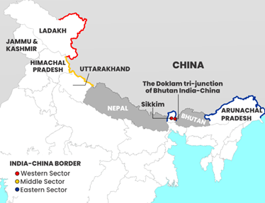
Structural Segmentation of the India-China Border
The border between India and China spans a total length of approximately 3,488 kilometers. It is not an officially demarcated international boundary but is functionally divided into three distinct geographic operational sectors separated by Nepal and Bhutan.
1. The Western Sector (Ladakh)
- Geographic Span: This segment covers about 1,597 kilometers along the Union Territory of Ladakh and the Chinese autonomous region of Xinjiang.
- The Line of Actual Control (LAC): The boundary here is completely non-demarcated and arose from the ceasefire line following the 1962 war. Overlapping claims lead to recurring patrolling face-offs.
- Historical Cartographic Claims:
- Johnson Line (1865): Proposed by the British civil servant W.H. Johnson, this boundary placed the entire Aksai Chin region within the princely state of Jammu and Kashmir. India considers this its rightful historical stance.
- MacDonald Line (1899): Also known as the Macartney-MacDonald Line, this alternative British alignment placed Aksai Chin under Chinese sovereignty. Beijing historically preferred variations of this boundary.
- Critical Friction Locations: Depsang Plains, Galwan Valley, Hot Springs, Gogra Post, and the northern/southern banks of Pangong Tso.
2. The Middle Sector (Himachal Pradesh & Uttarakhand)
- Geographic Span: This is the least disputed segment, extending approximately 545 kilometers across Himachal Pradesh and Uttarakhand.
- Border Attributes: The border here is broadly aligned with the natural high-altitude watershed. Maps have been largely exchanged for this sector, and both nations agree on its rough alignment, making it the most tranquil zone.
- Key Passes: Shipki La (Himachal Pradesh), Lipulekh, Mana Pass, and Niti Pass (Uttarakhand).
3. The Eastern Sector (Sikkim & Arunachal Pradesh)
- Geographic Span: This sector stretches across roughly 1,326 kilometers along the states of Sikkim and Arunachal Pradesh.
- The McMahon Line: Drawn during the Shimla Accord of 1914 between British India and Tibet, this boundary defines the formal frontier. While India adheres strictly to the McMahon Line as the legal international boundary, China rejects its validity, claiming that Tibet lacked the sovereign authority to sign a treaty and categorizing Arunachal Pradesh as “South Tibet.”
- Key Friction Points: Naku La (Sikkim), Tawang Sector, Bum La, and the Yangtse region of Arunachal Pradesh.
Major Institutional Border Management Mechanisms
To sustain operational stability and manage tactical frictions, India and China utilize a multi-layered diplomatic and military architecture:
- Working Mechanism for Consultation and Coordination (WMCC): Established in 2012, this institutional platform is led by Joint Secretary-level diplomats from the Ministry of External Affairs (India) and the Ministry of Foreign Affairs (China). It addresses peace and tranquility on the ground and coordinates border management.
- Special Representatives (SR) Dialogue: Formed in 2003, this higher-level forum features India’s National Security Advisor (NSA) and China’s Foreign Minister. The SR framework is mandated to seek a political settlement to the overarching boundary question through a three-stage process: guiding principles, framework agreements, and final line demarcation.
- Border Personnel Meetings (BPM): Conducted at designated border locations—such as Chushul-Moldo (Ladakh), Nathu La (Sikkim), and Bum La (Arunachal Pradesh)—to quickly defuse localized, tactical patrolling friction between military field commanders.
India’s Counter-Strategy and Infrastructure Developments
To offset aggressive cartographic developments and infrastructure asymmetric advantages along the border, India has heavily ramped up development initiatives through institutional channels:
- Vibrant Villages Programme (VVP): A Centrally Sponsored Scheme introduced by the Ministry of Home Affairs targeting the holistic development of border villages across Himachal Pradesh, Uttarakhand, Sikkim, Arunachal Pradesh, and Ladakh. The objective is to mitigate out-migration by upgrading connectivity, livelihood opportunities, and power access, thereby securing the frontline perimeter.
- Border Roads Organisation (BRO) Upgrades: India has accelerated strategic projects such as the Darbuk-Shyok-Daulat Beg Oldie (DS-DBO) Road in eastern Ladakh, the Sela Tunnel in Arunachal Pradesh (providing all-weather connectivity to Tawang), and the Atal Tunnel beneath the Rohtang Pass to ensure year-round, swift logistics and defense deployment capability.
Consider the following statements regarding the border frameworks and geography between India and China:
STATEMENT I: The Working Mechanism for Consultation and Coordination on India-China Border Affairs (WMCC) is a high-level political dialogue led specifically by the National Security Advisor of India and the Foreign Minister of China to negotiate a permanent settlement to the boundary question.
STATEMENT II: The McMahon Line was firmed up during the Shimla Accord of 1914 to delineate the frontier between British India and Tibet along the highest watershed ridge line of the Eastern Himalayas.
Which one of the following is correct in respect of the above statements?
(a) Both Statement I and Statement II are correct and Statement II is the correct explanation for Statement I
(b) Both Statement I and Statement II are correct and Statement II is not the correct explanation for Statement I
(c) Statement I is correct but Statement II is incorrect
(d) Statement I is incorrect but Statement II is correct
Solution
Correct Answer: (d)
Explanation
• STATEMENT I is INCORRECT: The statement inaccurately describes the leadership and core mandate of the Working Mechanism for Consultation and Coordination (WMCC). The WMCC is a diplomatic joint-secretary level mechanism established in 2012 to look after border management, maintain on-ground peace, and resolve active friction along the border. It is not led by the National Security Advisor and Foreign Minister; that specific political mandate belongs exclusively to the Special Representatives (SR) Dialogue platform.
• STATEMENT II is CORRECT: The McMahon Line serves as the functional frontier separating the eastern sector of India (Arunachal Pradesh) from Tibet. It was formally negotiated and firmed up during the Shimla Accord of 1914 between the British administrator Sir Henry McMahon and Tibetan plenipotentiaries, utilizing the geographic principle of the highest Himalayan watershed line. While India considers this an immutable international boundary, China continues to dispute its legal validity.
Therefore, Statement I is incorrect, but Statement II is completely correct.